Warburton Crossing (Simpson Desert)

Hi fellow travellers,

Has anyone been through Warburton Crossing since the start of April 2016?

I'm getting mixed information and wanting to find out if it's passable or if it's not, if anyone can have their best guess if it will be by mid-May 2016?

All other indicators I have found suggest it should be currently open.

Cheers
Back Expand Un-Read 0 Moderator

Reply By: Les - PK Ranger - Saturday, Apr 16, 2016 at 20:09

Saturday, Apr 16, 2016 at 20:09
Could be closed atm, latest DP Bulletin No. 525 – 15 April 2016 says "Warburton Crossing – Closed due to recent rain and localised flooding."
>> DPB525 <<
AnswerID: 598737

Reply By: Moke Spider - Saturday, Apr 16, 2016 at 20:18

Saturday, Apr 16, 2016 at 20:18
Cheers Les.

I have read that, but also read that while a few other travellers have also read that advice, at the crossing itself they have reported that it's signposted as 'Open' and is 'fine'.

I was hoping to verify that info.

Chris
AnswerID: 598738

Follow Up By: Les - PK Ranger - Saturday, Apr 16, 2016 at 21:04

Saturday, Apr 16, 2016 at 21:04
Ah, very confusing then with current access across.

Mid May, well being open all depends on if it rains up in QLD too, big catchment to Cooper, it can be flowing months after central QLD rains.
1
FollowupID: 867918

Reply By: Bob Y. - Qld - Saturday, Apr 16, 2016 at 21:39

Saturday, Apr 16, 2016 at 21:39
Moke,

There's a flood peak in the Diamantina between Durrie Station and Birdsville at the moment, but doubt if it will affect you in mid May.

If you check the BOM site it might have flood info on both the Georgina and Diamantina systems. They both have to "fill" Goyders Lagoon before running into the Warburton.

Bob

Seen it all, Done it all.
Can't remember most of it.

Lifetime Member
My Profile  My Blog  My Position  Send Message

AnswerID: 598742

Reply By: Moke Spider - Sunday, Apr 17, 2016 at 04:20

Sunday, Apr 17, 2016 at 04:20
Hi Bob,

Many thanks for that and yes, that was one of the Indicators I was looking at, but I don't know the area to that level of 'detail'. It's nice to have a second voice on that.

Cheers
Chris
AnswerID: 598746

Reply By: Kevin S - Life Member (QLD) - Monday, Apr 18, 2016 at 11:03

Monday, Apr 18, 2016 at 11:03
Lake Eyre Yacht Club web site says Goyder Lagoons are filling but only a trickle of water in Warburton Creek but that Warburton Crossing is closed.

Link Here Lake Eyre Yacht Club

Regards,

Kvin
Kevin
It is important to always maintain a sense of proportion

2019 Mitsubishi Cross

Lifetime Member
My Profile  My Blog  My Position  Send Message

AnswerID: 598802

Follow Up By: Moke Spider - Monday, Apr 18, 2016 at 11:16

Monday, Apr 18, 2016 at 11:16
Thank you Kevin, appreciated.

Chris
0
FollowupID: 867963

Follow Up By: Moke Spider - Tuesday, Apr 19, 2016 at 19:10

Tuesday, Apr 19, 2016 at 19:10
Kevin,

The LEYC Webpage is awesome to say the least and has a few very useful - real time - links. These are providing me with the answers that I am seeking.

In particular, this one for Warburton Crossing;-

https://www.waterconnect.sa.gov.au/Systems/SiteInfo/Pages/Default.aspx?site=A0021005&period=HRLY#Real-Time%20Data,Real-Time%20Data,Real-Time%20Data%20Plot

I know I've already said it, but sincere Thanks.

Cheers
Chris
0
FollowupID: 868022

Follow Up By: Bob Y. - Qld - Tuesday, Apr 19, 2016 at 20:26

Tuesday, Apr 19, 2016 at 20:26
What I noticed Chris, when we crossed the Warburton last Oct, was that it is, at the road anyway, just a minor channel. I'd suggest that if there was water at say 2M at the road crossing, there may well be a kilometer or two of floodplain that is inundated.

Less than 100kms downstream, on Cowarie Station, the Warburton channel is very impressive, and the flow is quite brisk. I'll let the photo do the talking.
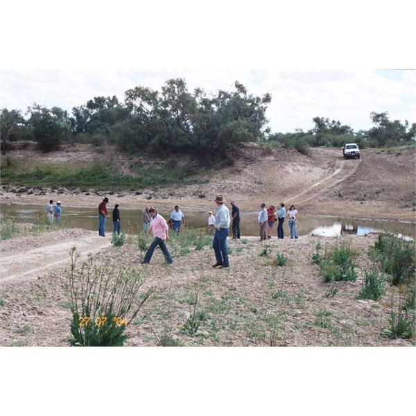


Bob

Seen it all, Done it all.
Can't remember most of it.

Lifetime Member
My Profile  My Blog  My Position  Send Message

1
FollowupID: 868025

Follow Up By: Moke Spider - Wednesday, Apr 20, 2016 at 04:56

Wednesday, Apr 20, 2016 at 04:56
Thanks for that Bob, rather interesting and scenic site!

I imagine it could get quite muddy and slippery too following a flood, but I've no doubt the track would also be closed at such times.

I see from the real time data from the SA Water Data webpage that a little further Up-stream (?) (at Poothapoota Water Hole) the water has ponded with literally only a trickle flowing to the crossing.

I'll be keeping an eye on all this over the next couple of weeks.
0
FollowupID: 868030

Sponsored Links