Finke south down the Old Ghan line, advice please?
Submitted: Monday, Jan 08, 2018 at 14:34
ThreadID:
136069
Views:
5459
Replies:
9
FollowUps:
10
This Thread has been Archived
Tracka D8
Hi all,
Planning for a trip for mid this year, part of is to hopefully follow the Old Ghan line heading South.
There is info for the Old Ghan from Alice to Finke, and South of
Oodnadatta, but I cannot find much on the section that is from Finke due south to
Oodnadatta.
Is there an accessible track that continues to follow the old rail line directly south of Finke past Crown Point, Duffield
Ruins, Wall
Creek, Abminga, Marakatina
waterhole, etc..??
If this is possible, can anyone advise the tracks to follow/map/conditions/camps etc...??
If this is not possible, any advice on the closest possible route to this direction would be appreciated please.
Reply By: DesF - Monday, Jan 08, 2018 at 14:51
Monday, Jan 08, 2018 at 14:51
Hi When we come home from Finke, we go to New Crown, Charlotte
Bore, Abminga, Eringa
Water Hole ( great
camping),
Hamilton,
Oodnadatta. about 285Ks
Great drive usually nothing to hard.
Cheers DEs.
AnswerID:
615971
Follow Up By: Peter_n_Margaret - Monday, Jan 08, 2018 at 18:05
Monday, Jan 08, 2018 at 18:05
In October 2016 we "escorted" another couple along that route in reverse who were driving a 200 series LC and towing a 23ft caravan. It was no problem at all, so you will have no dramas with the road.
Cheers,
Peter
OKA196 motorhome
FollowupID:
887169
Follow Up By: Member - McLaren3030 - Thursday, Jan 11, 2018 at 08:55
Thursday, Jan 11, 2018 at 08:55
Have followed this route twice, the last in 2016 towing an 18’ Off Road Caravan. No real problems, a Hema Navigator is great for ensuring you remain “on track”. Hema Maps for this area are also very useful for planning your trip.
Macca.
FollowupID:
887237
Reply By: IvanTheTerrible - Monday, Jan 08, 2018 at 18:45
Monday, Jan 08, 2018 at 18:45
We went south to north. Very remote but a nice drive but the track is pretty rough
AnswerID:
615974
Reply By: Peter_n_Margaret - Monday, Jan 08, 2018 at 21:30
Monday, Jan 08, 2018 at 21:30
Bad road? Depends on the personal view.
This is what we saw in October 2016. It was never much worse than this.
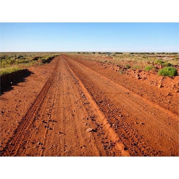
Road
More road
Cheers,
Peter
OKA196 motorhome
AnswerID:
615977
Follow Up By: IvanTheTerrible - Tuesday, Jan 09, 2018 at 18:45
Tuesday, Jan 09, 2018 at 18:45
Dont know were you were driving but I assume you didn't follow the direct route.
FollowupID:
887198
Follow Up By: Member - Blue M - Tuesday, Jan 09, 2018 at 21:30
Tuesday, Jan 09, 2018 at 21:30
I came through that way in October 2017 and it was pretty much the same.
The old Ghan road from Finke to
Alice Springs was like a highway.
The roughest bit of road I came across was going into
Chambers Pillar. It was a bit interesting.
Cheers
FollowupID:
887210
Reply By: Tracka D8 - Tuesday, Jan 09, 2018 at 07:45
Tuesday, Jan 09, 2018 at 07:45
Thanks to all for the info,
What do you think is an average speed on those tracks in that area ?
I realise road conditions can change each season/year, but just looking at the distances and realistic travel time so we can roughly plan some camps and average klms per day etc.
We usually take it fairly steady, no rush.
Also thinking of a possible detour across to Dalhousie for a night. The track back from Dalhousie>Pedirka>
Hamilton Stn is marked as very rough on my map, anyone been across that way recently?
AnswerID:
615983
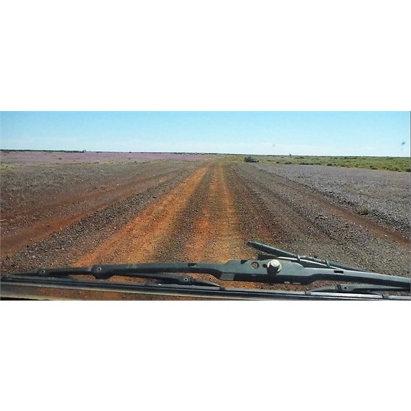
Follow Up By: Peter_n_Margaret - Tuesday, Jan 09, 2018 at 09:43
Tuesday, Jan 09, 2018 at 09:43
The roads in and out of Dalhousie tend to be much more corrugated (depending on your timing) because of the much higher traffic loads that they carry. I have seen some of them VERY corrugated at times.
Not sure exactly where this is, but somewhere between Eringa and Mound Dare (via
Bloods Creek) in May 2017. Again, not so bad really.......
Between Eringa and Mt Dare
Cheers,
Peter
OKA196 motorhome
FollowupID:
887181
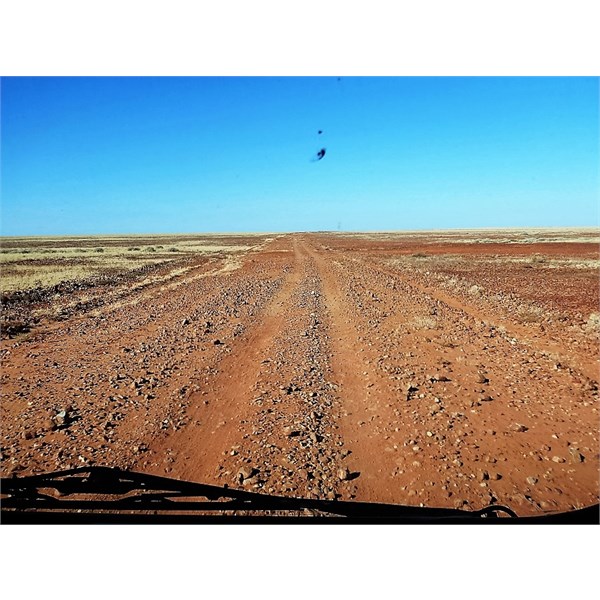
Follow Up By: KevinE - Tuesday, Jan 09, 2018 at 15:13
Tuesday, Jan 09, 2018 at 15:13
Just looking through my videos of that area & ironically, we have a video driving through what appears to be the same stretch of road as Peter's photo. That was the best section of road through there. The rest of the road into Dalhousie from Eringa was pretty ordinary IMO.
The short trip in & out of
the Painted Desert south of
Oodnadatta is
well worth the effort.
FollowupID:
887191
Follow Up By: Member - McLaren3030 - Thursday, Jan 11, 2018 at 09:01
Thursday, Jan 11, 2018 at 09:01
Road conditions can change overnight, so it is very hard to give you an accurate answer. Drive to the conditions is the best advice. In 2016, on some sections we were down to 20 Kph, and on others up to 80 kph. So like I said, drive to the conditions.
Macca.
FollowupID:
887238
Follow Up By: Les - PK Ranger - Friday, Jan 12, 2018 at 13:54
Friday, Jan 12, 2018 at 13:54
Peter, think you're talking about the direct road from north of Bloods turnoff, on the Dalhousie to Mt Dare Rd, the boulder field :)
I've only driven it twice, always travel out of the way a little now to go via Bloods Ck, a bit longer, but kinder on the vehicle and teeth !!
The district
Ranger said to me once, they grade that occasionally, but the underlying boulders come up within a week or two again.
They want to divert the road away form the problem, but each years budget doesn't provide enough funds.
FollowupID:
887280
Follow Up By: Les - PK Ranger - Saturday, Jan 13, 2018 at 10:31
Saturday, Jan 13, 2018 at 10:31
TrakaD8 "The track back from Dalhousie>Pedirka>
Hamilton Stn is marked as very rough on my map"
Have done it a few times,
well worth it for a look at Dalhousie
ruins, also further south the Cherrikanna
waterhole (artesian fed), and Perdika rail siding
ruins.
Last time we did it, we were looking forward to the sights, but not the usual 30km/hr or so, but it had just been graded and was an easy 50km/hr relaxing pace.
It's mainly
washouts / erosion through there that is the problems after each season, sometimes it gets affected more, other times it gets that bad they close it until repaired / graded.
You could inquire local parks office / district manager, they know the roads very
well and can advise perhaps.
FollowupID:
887291
Reply By: Member - DOZER - Wednesday, Jan 10, 2018 at 08:27
Wednesday, Jan 10, 2018 at 08:27
Last traversed this country in May 2017 and found the Alice to Finke leg the most challenging, deep sand with corrigations along the original Ghan. The tracks from ooodnadatta through Euringa (Kidmans favourite
camp spot) to Delhousie were good in comparison. Enjoy
AnswerID:
616000
Reply By: Member - nick b boab - Thursday, Jan 11, 2018 at 15:39
Thursday, Jan 11, 2018 at 15:39
G'day , in regards to your question ....
Is there an accessible track that continues to follow the old rail line directly south of Finke past ....
I sure thats the track we took last year when heading to finke desert race held on Queens birthday long week end ~ not the best time for traveling the alice finke section
after leaving finke heading south`ish side track that takes you through the station country to eringa , slow going in most
places wash out etc , but a really nice drive .
great
camp spot at eringa
water hole . after that its
well made road to
Oodnadatta
The section north of Finke you are driving on the actual old rail track and a certain amount of caution my be needed ,sandy , high drop off's .in
places the track cuts through hills & is one car wide & no where to get off if u have oncoming cars . this track is used by people going to Finke ..... aswel the track has the old railway nails scatted on the track .
AnswerID:
616027
Reply By: Bob Y. - Qld - Saturday, Jan 13, 2018 at 09:53
Saturday, Jan 13, 2018 at 09:53
Haven't been up to Finke yet, though been to Mt Dare a number of times. The
Oodnadatta-
Marree section is a great drive, as far as investigating all the old sidings and Algebuckna Bridge.
Camped at Beresford in Nov, 2015, away from the Siding, but it would be a top spot if caught there in cold, wet conditions, with a number of open fireplaces. From what I saw there appears to be families of birds resident in the old buildings, and have been for generations, judging by their droppings.
The
ruins at Bloods Ck are worth a look too.
Bob
AnswerID:
616057
Follow Up By: Allan B (Sunshine Coast) - Saturday, Jan 13, 2018 at 10:13
Saturday, Jan 13, 2018 at 10:13
.
Yes Bob,
Beresford Siding has interesting railway
ruins but a dusty spot when it hasn't been raining, which is most of the time!
Would have been a bit lonely back in the day with a train only occasionally.
I heard that the notice board once had a
sign that said "Tuesday's train is running early. It will arrive on Friday instead of Sunday". lol
FollowupID:
887290
Reply By: Member - McLaren3030 - Tuesday, Jan 16, 2018 at 16:12
Tuesday, Jan 16, 2018 at 16:12
Hi Tracka, Check Hema maps, as there is a road that runs south to
Oodnadatta but it does not follow the Old Ghan line directly. There are a few turns you need to make, but it is
sign posted.
From Finke, you head for New Crown, then turn right to Charlotte Waters. From Charlotte Waters, there are two ways you can go, one to Mt. Dare, and the other to Abminga
Ruins. Abminga
Ruins is more direct, but you will miss Mt. Dare.
From Abminga
Ruins, the track is less
well defined, but if you have a Hema Navigator (an accessory I highly recommend), you can bring the scale right down to ensure that you stay on the track. This section can also be quite rough, and stoney/rocky. This will take you to
Hamilton Station.
If you decide to go to Mt. Dare, after leaving Mt. Dare, you head for
Bloods Creek, then turn right and you will eventually join the Abminga/
Hamilton Station road approx. 20 kms south of Abminga
ruins.
From
Hamilton Station, the road is good gravel in most
places, and will take you to the
Oodnadatta Track. When you reach the
Oodnadatta Track, turn left and
Oodnadatta is about 17 kms away.
I have travelled this road twice, the first time in 2004, and the second in 2016 towing an 18' Off Road Caravan.
Macca.
AnswerID:
616132
Reply By: Tracka D8 - Monday, Jan 29, 2018 at 08:39
Monday, Jan 29, 2018 at 08:39
Thankyou to all for the info and pics.
We have narrowed an itinerary down and based on only having to do approx. 200 - 270 klms per day between camps through these tracks.
Taking our time, look around and enjoy it.
AnswerID:
616446