GPS- what are you folks using.
Submitted: Saturday, May 26, 2018 at 16:59
ThreadID:
136765
Views:
10961
Replies:
19
FollowUps:
20
This Thread has been Archived
Member - lyndon NT
Hi All
Just wondering what people are using these days? Without, may I add, going to a lappy in the car.
Interested in a unit that can have topo maps loaded onto it as
well as being able to upload files saved from Google earth.
Looked at the Hema offering...........HX-1
Interesting reviews on product review. With the sample number being enough to be credible.
Product Review
Your thoughts.
Cheers
Lyndon
Reply By: RMD - Saturday, May 26, 2018 at 17:10
Saturday, May 26, 2018 at 17:10
Lyndon
I am puzzled as to why you are considering one of those as the reviews are saying to avoid it.
I read similar comments a while ago. I liked the idea of a Hema unit but not that one.
AnswerID:
619175
Follow Up By: mountainman - Sunday, May 27, 2018 at 00:26
Sunday, May 27, 2018 at 00:26
All the reviews ive heard are go for the hn7
The latest one requires you to read and follow the manual as its quite indepth.
Lacks rev camera option.
And battery is an issue off charge as low hours of use.
Hn6 is pretty good but the hn7 is alot easier to use and has a reverse camera feed.
Im tempted to put the exploroz app from here on my phone and try that.
But i have memory/ storage issues on my phone....hmmm
FollowupID:
891426
Reply By: Kumunara (NT) - Saturday, May 26, 2018 at 17:37
Saturday, May 26, 2018 at 17:37
For on road I use the factory GPS provided with my vehicle.
For off-road I use oziexplorer on my Samsung tablet.
Works
well. Also a lot cheaper to put oziexplorer on my tablet than to buy a GPS such as Hema HX-1 which basically does the same thing.
AnswerID:
619178
Follow Up By: Crusier 91 - Saturday, May 26, 2018 at 19:08
Saturday, May 26, 2018 at 19:08
Basically the same??????????
I bet your oziexplorer doesn't loose gps position all the time then give up charging after 2 months like my HX-1. Couldn't use the dam thing through any of the Gibb!!!!
Having said that, I have a new unit coming under warranty but first it has to get shipped to
Perth from QLD before I can receive it in
Kununurra.Thank you Aussie Post.
Must mention though..........Many thanks to Dustin @
Kununurra 4wd spares WA & Steve @ ARB Morphett Vale SA and Hema for a quick warranty replacement.
FollowupID:
891408
Reply By: Member - Stephen L (Clare SA) - Saturday, May 26, 2018 at 18:20
Saturday, May 26, 2018 at 18:20
Hi Lyndon
The Hema HX 1 uses its own system and you can not add third party maps or transfer files from it like the old HN7.
The HX1 is a good unit, very different from past Hema Navigators, but you will find some people that do not like it.
Unlike the older units, that would start recording your track file the moment that you started moving, with the new HX1 you have to tell it to start recording if you want to keep a track file, that will then be uploaded the the Hema Cloud, and unfortunately can not be viewed on OziExplorer.
One good thing with this new idea, if you swap from off road to street mode, say comping into a large town into the normal street view, which I feel is as good as anything else at the moment, you do not lose any of the track file that you are recording, and then when you want to continue using the Off Road Tracks, it is a matter of just tapping the "H" Hema logo and then you have not lost any track recording.
Having said that, I still use a small SSD 11" computer to record all my track files on Ozi that I keep for every trip that we do, in conjunction with the HX1 for viewing as you drive.
Cheers
Stephen
AnswerID:
619179
Reply By: IvanTheTerrible - Saturday, May 26, 2018 at 19:06
Saturday, May 26, 2018 at 19:06
I use Hema Explorer and
EOTopo both on mobile devices.
AnswerID:
619180
Reply By: Member - Cuppa - Saturday, May 26, 2018 at 19:28
Saturday, May 26, 2018 at 19:28
Being a Mac user getting anything which uses Ozzie Explorer was of little use to me. We have used a Hema HX-1 for around 25,000kms so far & wouldn't want to be without it. It's not as 'state of the art' as I think it should be for the price but I think it's hard to beat it with anything else on the market. We did have a few issues with it intially but these seem to have been resolved by a software update late last year. We also find placing a heat shield around the back of it where it is mounted at the bottom of the windscreen helps reliability in hot weather.
It's internal battery life is only a couple of hours so using it for walking is less than ideal. We have a $200 hand held Garmin for that.
AnswerID:
619181
Follow Up By: Member - Boobook - Saturday, May 26, 2018 at 19:36
Saturday, May 26, 2018 at 19:36
Take a look at Memory Map Cuppa. They have Mac, IOS, PC and Android. You can share the maps across all platforms.
The software and a very good 250K map are free. You can buy detiailed maps and Hema maps.
FollowupID:
891409
Follow Up By: Member - Cuppa - Saturday, May 26, 2018 at 19:47
Saturday, May 26, 2018 at 19:47
Hi Tony, I did look at memory map at one stage, but found their whole setup terribly confusing & eventually worked out (with the aid of a more experienced MM user who couldn't understand why I was having problems) that whilst it was possible to run MM on a Mac That what I wanted to do (scan,calibrate & add maps I had bought) simply wasn't possible without using Windows based software which seemed crazy when the MM was available for Mac & iOS. I could have used a Windows emulator on my Mac, but wasn't keen, especially as the whole memory map set up seemed so non intuitive.
Anyway I plumped for the HX 1 & don't regret it. I can download higher detail maps for areas when needed for free, but so far have found the included maps to be up to the task I've used them for.
Just as an aside to those thinking about buying a navigator - I find being able to see where we are on a map at any given time tremendously reassuring. We use the turn by turn voice navigator when in towns we don't know.
FollowupID:
891413
Follow Up By: Member - Stephen L (Clare SA) - Saturday, May 26, 2018 at 19:53
Saturday, May 26, 2018 at 19:53
Hi Cuppa
I am also a beloved Mac user, but also have 2 Windows computers purely for OziExplorer.
The Windows 10 is user friendly and idea for using in the back of the car, while still using the HX1 for travelling and viewing where we at at a quick glance. The only reason why I still take the notebooks is so I can record my daily track files.
Cheers
Stephen
FollowupID:
891414
Follow Up By: Member - Cuppa - Saturday, May 26, 2018 at 20:01
Saturday, May 26, 2018 at 20:01
When needed we record our tracks on the HX1. A couple of times having done so has saved us a bit of anxiety when unsure of which way to turn on our way back to
camp.
I think if I were a Windows man I'd probably be using the exploroz mapping.
MrsTea has just bought a new iPad. I'll try to transfer the Hema4wd app I have on the now aging iPad3 with battery issues to it, but if I can't I'll be tempted to give
exploroz traveller app a go. I like to have a 'backup' for electrical navigation aids .... as
well as some paper maps. :)
FollowupID:
891416
Follow Up By: Member - Boobook - Sunday, May 27, 2018 at 05:55
Sunday, May 27, 2018 at 05:55
cuppa, be aware that the Hema 4wd app IS Memory Map rebadged. You can og into memory amp and put other maps on to it and transfer to other devices.
FollowupID:
891427
Reply By: The Explorer - Saturday, May 26, 2018 at 20:10
Saturday, May 26, 2018 at 20:10
Hello
I use a TwoNav Aventura (dicontinued model).
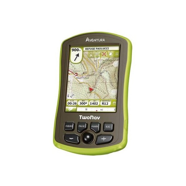
TwoNav Aventura
I convert all my maps (topo, air, satellite, geology, vegetation, historic..etc etc) to ecw and load up (bit of messing around sometimes to calibrate but easy enough when you know how). ECW is a good universal format that can also be used in OziExplorer, ArcView, Global Mappper and a range of other rmapping programs.
Data (waypoints and tracks) can be loaded and saved in the universal GPX format. You can load multiple track and waypoint files (no restricition).
Great battery life (8 hrs plus...largely dependant on screen brightness and time on)
Some people would probably find the screen a bit small for in car use but good size for also throwing in your pocket and walking which is where I use it most. Also has street mapping but generally use my phone/google maps for that these days.
Best GPS I have ever owned and I have had a few. I dont like the new range of units (purpose built in car units generally speaking - which I dont bother with) or programs that restrict the maps you can use to the ones you have to buy off them.
I can load just about any map that can be calibrated and is not some proprietary format which cant be viewed, calibrated or converted.
They have just release a new range of Aventura units
New Aventuras
with more bells and whistles but will stick with the old one for time being.
Cheers
Greg
| I sent one final shout after him to stick to the track, to which he replied “All right,” That was the last ever seen of Gibson - E Giles 23 April 1874 Lifetime Member
My Profile My Blog Send Message
Moderator |
AnswerID:
619182
Reply By: Frank P (NSW) - Saturday, May 26, 2018 at 22:16
Saturday, May 26, 2018 at 22:16
I'm using a Samsung tablet running EO Traveller and its premium map pack and also Ozi Explorer with a bucket full of maps. I run them simultaneously and swap between the two depending on what maps best cover the area I'm in and what level of detail I want.
We also carry a second tablet set up the same way as a backup.
AnswerID:
619184
Follow Up By: Allan B (Sunshine Coast) - Sunday, May 27, 2018 at 08:47
Sunday, May 27, 2018 at 08:47
.
I also use a Samsung 10" tablet with internal GPS.
Using OziExplorer and
EOTopo maps plus additional locality maps.
Works like a charm. Easy and never misses a beat.
Can be obtained for around $300.
Has the advantage of also performing as an email and internet browser etc when in cellular range.
Note that internal GPS is essential.
I started with Hema Hn5. Display too small and soon failed..... 12v input socket detached from board. Opened it and repaired it but observed the poor board construction so dumped it.
Mounts easily in the Troopy...................
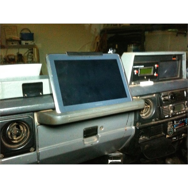
Tablet Mount
FollowupID:
891429
Reply By: Member - Paul B (WA) - Sunday, May 27, 2018 at 09:52
Sunday, May 27, 2018 at 09:52
I use my iPad (sim+wifi) with the
Exploroz EOTopo app in the car. At home I have computer with Ozi Explorer for more detailed trek manipulation and trip planning.
I also have Memory Maps on my iPad with the WA 100k map series ($99), which are great for me as the have the old Goldfields woodline alignments on them (many long since overgrown) but as that’s my patch that’s real handy. Also other historical info as
well as better contour info.
But my go-to generally is
EOTopo.
My iPad is mounted on an Arkon floor mount and is very elegant in it’s simplicity and lack of wires. I often toss a Garmin eTrex gps on the dash just to record a track in case there is a failure elsewhere but rarely need to go back and look at it.
AnswerID:
619188
Reply By: Bob Y. - Qld - Sunday, May 27, 2018 at 11:06
Sunday, May 27, 2018 at 11:06
I just use medium priced Garmin GPS, for in town Nav, and as speedo.
Use an iPad with Hema 4WD maps for remote areas, and logging trips and POI's.
Works
well for me,
Bob
AnswerID:
619192
Follow Up By: 9900Eagle - Sunday, May 27, 2018 at 15:25
Sunday, May 27, 2018 at 15:25
I use the same Bob and have no problems with either. Just had a look and my on road Garmin is 6 years old in a couple of weeks, it hasn't faulted and it's still getting free map updates.I also run honkie maps on it which are ok for basic off road
I use it as a speedo as
well and never look at the vehicle one unless I lose sat signals which can happen in heavily wooded mountain terrain.
Ipad has also worked fine with Hema, just a bit expensive to purchase against a tablet. The again it just works.
FollowupID:
891436
Follow Up By: Bob Y. - Qld - Sunday, May 27, 2018 at 18:34
Sunday, May 27, 2018 at 18:34
Only complaint I've had with using IPad, Slow, was heavy power use. Found using 2 amp USB helped a lot, then a bloke suggested to switch Flight Mode on. Seems to be the go.
Bob
FollowupID:
891440
Follow Up By: 9900Eagle - Monday, May 28, 2018 at 05:15
Monday, May 28, 2018 at 05:15
Thanks Bob, will try it
FollowupID:
891442
Reply By: Member - nick b boab - Monday, May 28, 2018 at 06:16
Monday, May 28, 2018 at 06:16
Gday Lyndon : as you say the reviews are very interesting you do not see many good reviews for this unit ( hx1) but I have one and think it is very good .... i don't have any the problems you read about . Overheating and lost GPS etc are probably the most common complaints , but in my opinion if you keep your updates up to date the unit works exceptionally
well.
Has Good battery life a very sturdy mounting bracket for the windscreen . And obviously Hema Maps are very good .
AnswerID:
619208
Follow Up By: Member - lyndon NT - Tuesday, May 29, 2018 at 07:19
Tuesday, May 29, 2018 at 07:19
Hi
Thanks for your thoughts. I think the overheating would rule it out. We live in
Darwin. My around town Garmin has been in baking sun for four years now and hasn't died. So I think there must be a design issue there.
Cheers
Lyndon
FollowupID:
891460
Follow Up By: Member - nick b boab - Wednesday, May 30, 2018 at 06:09
Wednesday, May 30, 2018 at 06:09
The overheating problem is nothing to do with the ambient temperature... it is a software issue which has been rectified by updates
Since the update I can assure you
mine no longer has any overheating / shut down problems even on the hottest summer day in South Australia .
FollowupID:
891493
Reply By: Member - David M (SA) - Monday, May 28, 2018 at 08:57
Monday, May 28, 2018 at 08:57
OT Lyndon but I like your thoughts. A poetic take on " Get off ya arse "
Dave.
AnswerID:
619210
Reply By: Member Kerry W (WA) - Monday, May 28, 2018 at 11:32
Monday, May 28, 2018 at 11:32
Just another perspective and opinion....Have tried everything from Garmins, Hema Navigators etc have finally settled on what is FOR ME the simplest most generally useful solution- iPad mounted on a
Tabtite cradle With an iPhone 7+ with the same apps for handheld or in the car. I run EOTraveller and Memory map.
I just find that with the iPhone/iPad setup I need to carry less gear and have fewer headaches keeping up with instructions and learning curves.
The tablet/phone combo also lets you use community based traffic congestion beating apps like
WAZE when navigating through cities.
Also if I go overseas I use
maps.me which even displays roads,
walking tracks etc globally. (We recently trekked through Torres del Paine in Patagonia and the
walking tracks and GPS navigation were spot on...)
In the bush I use Google maps' satellite imagery as a visual reference for my intended destination. If there is no data reception where I am heading, prior to departure I zoom into the area I intend to visit and I have an overhead view of the landscape tracks and features, then I shut it down till I get there. Most devices will store a limited portion of the last satellite images viewed and I can use this to assist to a limited degree.
My two bobs worth...
| Kerry W (Qld)
Security is mostly a superstition. It doesnt exist in nature. Life is either a daring adventure or nothing.
-Helen KellerLifetime Member
My Profile My Blog Send Message |
AnswerID:
619213
Reply By: Member - McLaren3030 - Monday, May 28, 2018 at 12:22
Monday, May 28, 2018 at 12:22
Hi Lyndon,
I have a Hema HX-1, bought early last year, and have only had one problem with it. The problem I have had is that the unit "stalled" twice. The first time was near
Surveyor Generals Corner in WA, and the second time was on my way home from our last trip to the
Simpson Desert. From what I have been lead to believe, most of the problems that others have had were caused by the first software update that was issued in the middle of last year. I understand that the second software update that was issued late last year has resolved most of the issues. Unfortunately, I have a Mac, and the Hema Software is not supported by Mac, so I cannot download the upgrades.
Macca.
AnswerID:
619215
Follow Up By: Member - Stephen L (Clare SA) - Monday, May 28, 2018 at 19:26
Monday, May 28, 2018 at 19:26
Hi Macca
With the new HX1, all updates are carried out WiFi through the HX1 itself and not through a computer.
When you first set the unit up from the box, one of the things that you would have been ask is to connect to a WiFi signal and it would have check then for updates.
Every time that you turn the unit on and you are within a WiFi signal, it will check for any updates.
I also run Macs, but use Windows computers for OziExplorer only.
Cheers and all the best with the updates.
Stephen
FollowupID:
891454
Follow Up By: Member - Stephen L (Clare SA) - Monday, May 28, 2018 at 19:38
Monday, May 28, 2018 at 19:38
Hi Macca
Just for curiosity, I have just turned on my HX1 and there was an important GPS update.
This was again done by itself and you can do yours as simple as this.....
When the unit boots up and you are on your home screen, tap on the cog symbol on the right hand side of the screen alongside the main Hema logo.
When you tap on this, it will go to the black screen for the Device Settings.
Make sure that you are connected to your home WiFi signal.
Then the seventh item from the top is the "Check for Updates Now"
Tap that and it will open the Check for Updates Now window with the Download and install updates, with 2 options of either cancel or OK
Tap the OK button and then just follow the prompts.
Cheers
Stephen
FollowupID:
891455
Follow Up By: Member - McLaren3030 - Tuesday, May 29, 2018 at 14:12
Tuesday, May 29, 2018 at 14:12
Hi Stephen,
Thanks for the info. When I first bought my HX-1, I did not have a WiFi Modem so I did not turn this function on. I have since changed over to a WiFi Modem.
I have just completed the updates (4 of them) as per the info you provided.
Regards, Macca.
FollowupID:
891473
Follow Up By: Member - Stephen L (Clare SA) - Tuesday, May 29, 2018 at 19:23
Tuesday, May 29, 2018 at 19:23
Hi Macca
That's good to hear.
Not sure if have also been made aware, but you can also get greater detailed maps via Wifi when you click on an area, and zoom in, and you then download the greater tilespd map which you use at a later date.
All the best.
Stephen
FollowupID:
891478
Reply By: Member - Mark C (QLD) - Monday, May 28, 2018 at 20:03
Monday, May 28, 2018 at 20:03
I use Hema phone app and
EOtopo. Both great but the EO topo is really great and has so much detail.
AnswerID:
619217
Reply By: Mike & Kendra Prado 2 - Monday, May 28, 2018 at 22:25
Monday, May 28, 2018 at 22:25
I use the Hema HX1 and found it easy. Everything done online, and far less cumbersome than H7 which wasn’t too shabby in its day. However planning your own
routes, uploading third party route ,recording a route for future use and uploading to the cloud is
miles ahead of the old technology. Read all the negative reviews: mostly unfounded and written by techno immigrants. It just takes a bit of reading , watch a few youtube videos and you’ll not regret buying this model ! Cheers Mike
AnswerID:
619218
Reply By: Michaeljp - Tuesday, May 29, 2018 at 15:09
Tuesday, May 29, 2018 at 15:09
For on road i use my Garmin Nuvi top of the line one not sure of the model number 3795LMT or similar. and for off road i use Hema maps on iPad mini. Just remember the majority of your trip will be on road.
AnswerID:
619230
Reply By: Member - lyndon NT - Saturday, Jun 02, 2018 at 17:11
Saturday, Jun 02, 2018 at 17:11
Thanks for everyone's input, much appreciated.
Plenty of food for thought.
Regards
Lyndon
AnswerID:
619310
Reply By: Member - McLaren3030 - Monday, Jun 04, 2018 at 12:00
Monday, Jun 04, 2018 at 12:00
Lyndon NT,
Zenec (
https://zenec.com.au/product-category/universal/z-n626/) make a replacement head unit with the Hema HN-7 already installed. It is a digital radio, so you will also need a Digital Aerial as
well. Not cheap, around $1,700 from memory, but this is an option for a complete built in unit.
Macca.
AnswerID:
619341
Follow Up By: Member - lyndon NT - Tuesday, Jun 05, 2018 at 17:37
Tuesday, Jun 05, 2018 at 17:37
Hi Macca
thanks for the info, I drive a Troopy though :-)
FollowupID:
891628
Follow Up By: Member - McLaren3030 - Wednesday, Jun 06, 2018 at 10:35
Wednesday, Jun 06, 2018 at 10:35
Lyndon, you can still insert a Zenec into a 70 Series Landcruiser, it just requires a mounting kit.
Macca.
FollowupID:
891652
Reply By: Baz - The Landy - Tuesday, Jun 05, 2018 at 10:40
Tuesday, Jun 05, 2018 at 10:40
Hi Lyndon
I use a Panasonic Toughbook (purchased refurbished unit) with Oziexplorer.
It is as described "tough", holds up to the corrugations, and doubles as my computer on the road.
You can read more about it in a blog I wrote,
Panasonic Toughbook.
Good luck with your deliberations.
Cheers, Baz - The Landy
AnswerID:
619363