EOTopo Vector is now live & free online!
Submitted: Thursday, Feb 14, 2019 at 14:56
ThreadID:
137809
Views:
6533
Replies:
14
FollowUps:
19
This Thread has been Archived
ExplorOz Team - Michelle
Have you been paying attention?
For those that have read my comments in
Thread 137755 regarding the future of
EOTopo map data outputs, you will be interested to know that
EOTopo online VECTOR IS NOW LIVE (as a demo).
Click here -
EOTopo Online to view it, BUT NOTE below...
NOTE: By default the map that is open is not the new Vector map, you need to look below that and click the heading "
EOTopo 2018.1 Vector". This will open the new Vector map window. Make sure you click the symbol to enlarge the map to full screen for best viewing.
In this demo online vector system, we are offering you some features to use with the map including;
1. zoom to Level 22 (scale symbol bottom left shows 1m), map scale output is 1: 550 (0.55K) as you can see this is ridiculously close and in reality, it's impractical but we have the data and we can output it, so have some fun playing with it :)
2. Rotate & Pitch (3D) controls - very nice! Notice road labels rotate etc
3. Fly To option (to quickly pan the map to pre-set locations) - very nice interface
4. zoom increments by whole levels (eg. Level 9 to Level 10) by using the + symbol, but if you use a mouse with scroll wheel the zoom increments are 0.1 increments so Level 9 to Level 9.1, to Level 9.2 etc). As per current raster tile zoom system, more detail is revealed as you zoom closer but the vector output is a much smoother system
5. press the GPS symbol in the top right to fly and lock to your current position
We didn't have this ready to feature in the recent newsletter, so just posting here for your information today. We will release another newsletter early next week with further information. Please feel welcome to ask questions etc.
Reply By: Idler Chris - Thursday, Feb 14, 2019 at 15:56
Thursday, Feb 14, 2019 at 15:56
Hi Michelle,
This looks very exciting.
You say "This map supports zoom to level 22 however it may be reduced in final as anything above 19 is difficult to use in reality."
Why is this? I would have thought more zoom levels the better because you do not have to use them.
Cheers,
Chris
PS. Happy birthday for the other day, hopefully your family spoilt you.
| What other people think of me is none of my business.
Do unto others what you would have them do unto you.
The word "hate" is not in my vocabulary. Lifetime Member
My Profile My Blog My Position Send Message |
AnswerID:
623842
Follow Up By: ExplorOz Team - Michelle - Thursday, Feb 14, 2019 at 18:50
Thursday, Feb 14, 2019 at 18:50
yes great if you have the data to show at those levels but in the
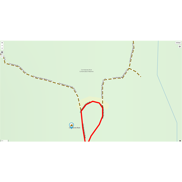
EOTopo mapset by the time you've zoomed into Level 14 we have loaded all the data layers so no matter how far you zoom in you don't actually reveal any EXTRA data but certainly it gets easier to view when features are closer together as it spreads them out more on the screen and especially with
walking tracks you can view all the twists and turns at the higher zoom but again, even by Level 17 this is more than sufficient. I did some comparisons of the walk track at Corroborree Rock just off the
Ross Highway in the NT, east of
Alice Springs. Each whole zoom level number increases magnification by 100% (ie. halves the scale), or 2x magnification whichever way you want to look at it.
FollowupID:
897139
Reply By: rocco2010 - Thursday, Feb 14, 2019 at 16:24
Thursday, Feb 14, 2019 at 16:24
Hi Michelle
Looks good.
But when I go to full screen on iPad it gives me this message. Is there something in my settings that is wrong?
Message
AnswerID:
623843
Follow Up By: ExplorOz Team - Michelle - Thursday, Feb 14, 2019 at 18:33
Thursday, Feb 14, 2019 at 18:33
Looks like iOS have introduced changes to their full screen option, as both the raster map and the vector map windows are behaving strange in the Apple browser environment that it wasn't doing previously. We'll take a look at what we have to change and get it sorted.
FollowupID:
897138
Reply By: Member BarryG - Thursday, Feb 14, 2019 at 17:27
Thursday, Feb 14, 2019 at 17:27
Hi Michelle,
Agree, looks great!
But I also have a problem with full-screen on my iMac. Results in full black screen containing a wide window across the middle third of
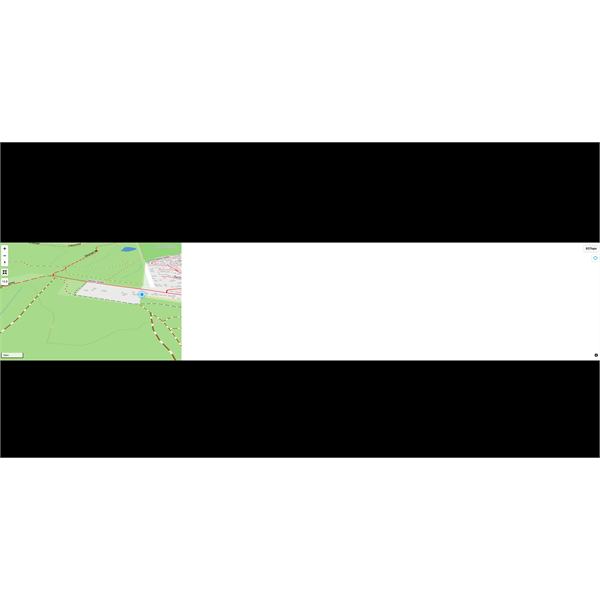
VectorFullScreen
the screen. This window has the original map window on the left and white screen on the right.
Regards
Barry Gange
Anglesea, Vic
AnswerID:
623846
Follow Up By: ExplorOz Team - Michelle - Thursday, Feb 14, 2019 at 18:33
Thursday, Feb 14, 2019 at 18:33
Thanks guys,
looks like iOS have introduced changes to their full screen option, as both the raster map and the vector map windows are behaving strange in the Apple browser environment that it wasn't doing previously. We'll take a look at what we have to change and get it sorted.
FollowupID:
897137
Follow Up By: Member BarryG - Friday, Feb 15, 2019 at 15:04
Friday, Feb 15, 2019 at 15:04
Michelle,
Is there any plan to incorporate some sort of altitude representation, i.e. 3D contour view?
Barry Gange
FollowupID:
897178
Reply By: Frank P (NSW) - Thursday, Feb 14, 2019 at 18:55
Thursday, Feb 14, 2019 at 18:55
Look great, Michelle, but I too have glitches in the Windows and Android environments.
On my PC (Win7 with Opera, both fully updated), I get the following when I zoom in beyond 10.8. It is on every tile on the screen in both full screen and part screen:
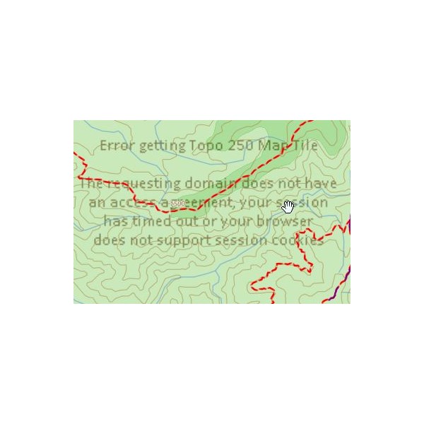
Win7 and Opera
It is the same on my Android tablet (Samsung Tab S2 9.7 fully updated, native browser, 4:3 screen ratio) but with a letterbox window that looks to be 16:9 or skinnier:
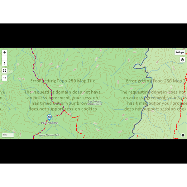
Tablet screenshot
In both I can zoom in to the max despite the tile messages.
Will you eventually be getting this into EO Traveller? I hope so!
Cheers
AnswerID:
623849
Follow Up By: ExplorOz Team - Michelle - Thursday, Feb 14, 2019 at 18:59
Thursday, Feb 14, 2019 at 18:59
David says it should work but geez, in your Windows environment, Win 7 is not even a supported operating system so its possible the security protocol is not compatible with our map tile server. Try a different browser - eg. Chrome.
The fact that you're getting it also in Android might indicate you have some sort of security software that is interfering with passing your security token to access our tile server.
David - says please try with Chrome and tell us what you get.
FollowupID:
897140
Follow Up By: Frank P (NSW) - Thursday, Feb 14, 2019 at 21:44
Thursday, Feb 14, 2019 at 21:44
Same with Chrome and Firefox :-(
PC security is Windows firewall, standard, not customised in any way and Microsoft Security Essentials.
Android on the tablet is bog standard, fully updated to 7.0.
I just checked it on my phone, Samsung S7, Android 8.0.0. Same result except that the phone doesn't do the letterbox thing.
.
I am on Telstra NBN with a bog standard, unmodified modem-router.
As an additional test, I turned WiFi off on both small devices, so only Telstra data via 4G to provide internet, and the same result.
Cheers
FollowupID:
897144
Follow Up By: ExplorOz Team - Michelle - Friday, Feb 15, 2019 at 00:09
Friday, Feb 15, 2019 at 00:09
Frank David says to go to
Places and open a map and see if that works ok, then come back to
EOTopo. Also just check the domain you are using is
https://www.exploroz.com as if using another referrer it won't allow access. There is a problem with your security token granting access that needs to be solved.
FollowupID:
897150
Follow Up By: Frank P (NSW) - Friday, Feb 15, 2019 at 10:20
Friday, Feb 15, 2019 at 10:20
Michelle,
I checked the domain. It is secure HTTPS.
Now at the airport, Telstra 4g only,
well away from any home influence. No change to what I reported.
I went to
Places, zoomed a map in full screen to max zoom with no issues.
Just confirming that even with those tiled messages there is no loss of functionality. I can zoom right in, tilt and rotate.
As of this morning the letterbox behaviour on my 4:3 tablet is no longer occurring :-)
Regards
Frank
FollowupID:
897158
Follow Up By: ExplorOz - David & Michelle - Friday, Feb 15, 2019 at 12:30
Friday, Feb 15, 2019 at 12:30
Frank,
The issue you are seeing are the lower opacity background tiles that are used to provide shaded relief. I had a look at ths system late last night and made a few updates - can you check again and report if they are now loading please?
David
FollowupID:
897169
Follow Up By: Frank P (NSW) - Friday, Feb 15, 2019 at 16:26
Friday, Feb 15, 2019 at 16:26
David,
The issue appears fixed.
Well done! I checked with the native Samsung browser and also Chrome, all good.
I'm away from home with only the tablet and phone, so unable to check the PC but logic suggests it will be ok too.
Many thanks. Looking forward to a Traveller update in due course!
Cheers Frank
FollowupID:
897180
Reply By: ExplorOz Team - Michelle - Thursday, Feb 14, 2019 at 19:04
Thursday, Feb 14, 2019 at 19:04
Make sure you click to open each image - otherwise you're only seeing thumbnails
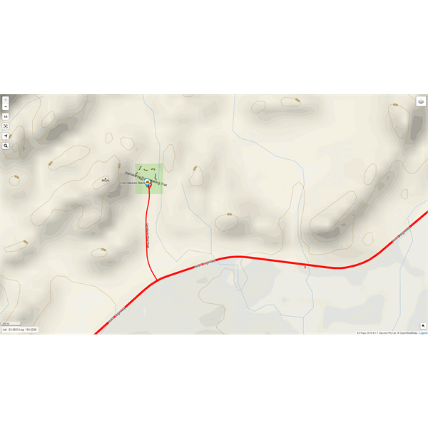
Example - Level 16
Example - same map area at Level 19 zoom Vector
Example - same place at Level 22 zoom vector
screen shots taken on my 21" monitor - Windows 10 PC, using Chrome browser
AnswerID:
623850
Reply By: Member - Alan H (QLD) - Friday, Feb 15, 2019 at 08:43
Friday, Feb 15, 2019 at 08:43
I am using windows 10 on a laptop and the map performance is excellent with no hitches as described by others. Looks very impressive and i will certainly look at this for using offline on Oziexplorer in the future
AnswerID:
623857
Follow Up By: ExplorOz Team - Michelle - Friday, Feb 15, 2019 at 11:19
Friday, Feb 15, 2019 at 11:19
Thanks Alan,
Yes the issues reported by some others are local to their device/browser etc but just trying to help them find some solutions and maybe if we hear of a pattern can look at the sensitivity in our map server security protocols but at this stage looks localised.
FollowupID:
897160
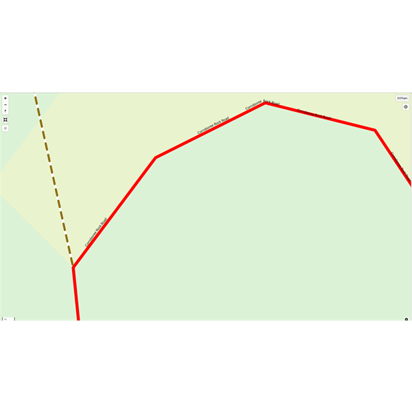
Reply By: Member - Rod N (QLD) - Friday, Feb 15, 2019 at 16:45
Friday, Feb 15, 2019 at 16:45
The new map works
well but there are a number of errors in the actual content. Some features that were on the original map are not on the new map, eg near
Toowoomba the
intersection of the
Warrego Highway and Troys Road is incomplete.
Map
There are further errors around the
Toowoomba area which I will try to include in an email.
AnswerID:
623873
Follow Up By: ExplorOz Team - Michelle - Friday, Feb 15, 2019 at 17:21
Friday, Feb 15, 2019 at 17:21
There are bound to be errors in the roads data layers especially with the conflation data where we've merged street level data into the topo data on the outskirts of urban areas - we did this for the first time last year in the 2018 edition but it wasn't as apparent at the lower scales but yes now that you can zoom right in at greater levels the errors are more pronounced. We will be doing a full road data layer conflation again for the production of the 2019 data. But yes, if you are seeing things, don't hold back letting us know. State and name of
intersection roads is required. A screen shot of how we've got it currently too please and either another screen shot if you have it of what it should be, or at least clear description of the change required. We cannot guess and it saves a lot of time if you are precise - you are great with your feedback last year Ron - so keep it up!
FollowupID:
897182
Reply By: Idler Chris - Friday, Feb 15, 2019 at 22:49
Friday, Feb 15, 2019 at 22:49
Hi Michelle, there is a road that goes from Pinjin to the Tropicana Gold
Mine north east of Kalgoorlie. This road is so good that the road trains can travel the whole distance at their maximum permitted speed (80 kph I think) and be able to pass each other without slowing down. There is a big
sign at the Pinjin end saying it is a private road. It was built some years ago and I have never seen it on any other map, presumably because it is a private road. I notice that this road is on your new vector map which I think is great, but I do not know if this is what you intended or not. Unlike most other roads in the area it does not have a name on it.
Cheers, Chris
| What other people think of me is none of my business.
Do unto others what you would have them do unto you.
The word "hate" is not in my vocabulary. Lifetime Member
My Profile My Blog My Position Send Message |
AnswerID:
623880
Reply By: Member - Boobook - Saturday, Feb 16, 2019 at 06:57
Saturday, Feb 16, 2019 at 06:57
Michelle,
Interesting and nice.
Can you please explain the benefit of the Vector map over the Raster maps for EO?
Vector maps are usually used for turn by turn instructions. It is EO's plan to introduce that for offroading?
AnswerID:
623883
Follow Up By: ExplorOz Team - Michelle - Saturday, Feb 16, 2019 at 15:48
Saturday, Feb 16, 2019 at 15:48
At this point, the big push is to deliver more detailed map scale offline and vector will enable us to do that. Raster is limited due to being image and resolution based and once we go past 144K map tile delivery in raster the files sizes are just unwieldy but we want to deliver the offline map at around 2-9K (1:2000). Vector can do that, as this online demo shows you. That is the same mapset just in vector output. Vector is resolution independent and handles rotation, 3D pitch etc so offers more flexibility for the user to set the map orientation the way that suits them. Currently if you use our Track Up mode in the app for example the road name labels do not rotate as the map rotates - that is a limitation of raster, yet vector manages that seamlessly. Vector will also enable us to offer different setting profiles to different user groups - eg cyclists vs trail runners vs drivers vs hikers - ie. different hierarchical defaults in the data layers to optimise what is more important to each user group. Of course, there is a lot more to it, but that's really how I see it. David would have a much more technical response.
FollowupID:
897217
Reply By: RobMac (QLD_Member) - Saturday, Feb 16, 2019 at 22:30
Saturday, Feb 16, 2019 at 22:30
From what I've seen of this so far, I'm impressed. I've looked where we are heading to in July (ie:
Madigan Line) and what is shown is great....
In regards to the thumbnails when there indicates more then one and if u keep zooming in they eventually separate and u see each thumbnail. When this becomes offline and u click on the thumbnail, is the plan to see the attached photos as
well?
Do u plan to still use dedicated icons for the POI's (if that makes sense)
btw: I don't suppose this will be ready for offline use before June/July this year :)
AnswerID:
623900
Follow Up By: ExplorOz Team - Michelle - Monday, Feb 18, 2019 at 14:13
Monday, Feb 18, 2019 at 14:13
RobM you are referring to the
Places clusters which we have chosen to display on this version of our map via the webbrowser. If you go to the
Places section on our website you'll also see it there.
There are over 90,000 Place POIs - so at lower zoom levels it is impossible to show them all as they would be all overlaping and it would be a very messy map - so instead we displayed "Clusters" - the number show how many
places in that region and if you click the clusters the map will automatically zoom in a bit to enable these clusters to split off into smaller clusters until eventually you are zoomed in sufficiently that all the individual Place icons/POIs can be displayed in their exact GPS position. Once at that level the POI will show its individual icon for Place by Type. The map panel in the
Places section of our website works exactly the same.
All this is already available offline when using our app
ExplorOz Traveller.
FollowupID:
897286
Reply By: Member - Rod N (QLD) - Sunday, Feb 17, 2019 at 12:55
Sunday, Feb 17, 2019 at 12:55
Are the
EOTopo maps down for others or is it just me. I haven't been able to access them since last night. The
EOTopo 2018 gives a 'Tile
server error'.
The vector map for
Brisbane shows a blue map but with clickable place icons.
Did I break it taking screen shots to submit amendments to correct errors?? :(
AnswerID:
623915
Follow Up By: Member - Rod N (QLD) - Sunday, Feb 17, 2019 at 20:50
Sunday, Feb 17, 2019 at 20:50
All OK now. I closed and reopened the page in a TAB in Microsoft Edge.
FollowupID:
897256
Reply By: Member - Mark C (QLD) - Tuesday, Feb 19, 2019 at 16:41
Tuesday, Feb 19, 2019 at 16:41
Just opened on my iPad 9” and wow. It was so smooth and went into zoom on lots of desert
places and worked both with the + and - and also using fingers as the zoom. Very cool.
AnswerID:
623974
Reply By: Member BarryG - Wednesday, Feb 20, 2019 at 10:30
Wednesday, Feb 20, 2019 at 10:30
Michelle & David,
I had indicated earlier that the full-screen option was not working on my iMac. It also fails on my MacBook Air in a similar fashion.
However, the failure occurs in Safari only - it works perfectly in Chrome!
(this may help you to diagnose the Safari problem. If I can help, let me know.)
Regards
Barry Gange
AnswerID:
623985
Follow Up By: rocco2010 - Wednesday, Feb 20, 2019 at 11:19
Wednesday, Feb 20, 2019 at 11:19
I had issues with the full screen on an iPad in
EoTopo since an IOS upgrade a month or so and they were the same on the vector version.
Switched to the Chrome app today as suggested and
EoTopo now works fine but there is no “full screen” button in the vector version.
Likewise when looking at it on an iPhone
Hope this makes sense
Cheers
FollowupID:
897356
Follow Up By: rocco2010 - Wednesday, Feb 20, 2019 at 11:23
Wednesday, Feb 20, 2019 at 11:23
Here is a screen shot
Screen
FollowupID:
897358
Reply By: cruiser80 - Wednesday, Feb 20, 2019 at 11:38
Wednesday, Feb 20, 2019 at 11:38
It's looking great but I notice that
creek and river names don't seem to appear very much in the new version.
Example: The Bogan River through
Nyngan has no name showing on it. Nor other creeks in that area. They are there in the raster version but I'm not seeing it on the vector version.
AnswerID:
623987
Follow Up By: Member BarryG - Thursday, Feb 21, 2019 at 07:25
Thursday, Feb 21, 2019 at 07:25
I agree cruiser80. No waterways in Safari or Chrome on IOS. But in Chrome on IPad mini4, I get “Loading resources” forever (and no full screen button).
Barry
FollowupID:
897382
Follow Up By: ExplorOz Team - Michelle - Friday, Feb 22, 2019 at 15:17
Friday, Feb 22, 2019 at 15:17
Probably just haven't turned all the feature layers on for some reason, remember this is just a demo and is not live in production so has been done quickly, not intended to be 100% at this stage.
FollowupID:
897427