Floodwaters filling Goyders Lagoon
Submitted: Friday, Mar 01, 2019 at 21:10
ThreadID:
137881
Views:
5234
Replies:
3
FollowUps:
7
This Thread has been Archived
Teraa
Looks to be just the one big hit with the levels dropping in
Birdsville already.
Sat. Image
Reply By: Bob Y. - Qld - Saturday, Mar 02, 2019 at 06:29
Saturday, Mar 02, 2019 at 06:29
What is the link for these satellite images please, Teraa?
Thanks,
Bob
AnswerID:
624135
Follow Up By: DiggZ - Saturday, Mar 02, 2019 at 20:29
Saturday, Mar 02, 2019 at 20:29
It looks like this one, I haven't worked out how to get any place names. I had to change the corrected reflectance in layers to see the
water better.
https://worldview.earthdata.nasa.gov/?p=geographic&l=MODIS_Aqua_CorrectedReflectance_Bands721,VIIRS_SNPP_CorrectedReflectance_TrueColor(hidden),MODIS_Aqua_CorrectedReflectance_TrueColor(hidden),MODIS_Terra_CorrectedReflectance_TrueColor,Reference_Labels(hidden),Reference_Features(hidden),Coastlines&t=2019-03-02-T00%3A00%3A00Z&z=3&v=118.81588902900378,-38.49587208385876,159.74574401008832,-13.605247083858739
FollowupID:
897552
Follow Up By: Teraa - Saturday, Mar 02, 2019 at 22:32
Saturday, Mar 02, 2019 at 22:32
https://worldview.earthdata.nasa.gov/?p=geographic&l=MODIS_Aqua_CorrectedReflectance_Bands721,VIIRS_SNPP_CorrectedReflectance_TrueColor(hidden),MODIS_Aqua_CorrectedReflectance_TrueColor(hidden),MODIS_Terra_CorrectedReflectance_TrueColor,Reference_Labels(hidden),Reference_Features(hidden)&t=2019-03-02-T00%3A00%3A00Z&z=3&v=136.13547926682736,-28.138183593750178,142.9115929236783,-25.026855468750178
Try this one it should have place names ,let me know I’d it doesn’t work
You have to,play with the maps layers to get different aspects.
The next thing to watch is the
creek marker at the end of the Goyders link below.
Because as the channel gets smaller you don’t always see it with these sat. Images. Poothapoota WH.
http://www.bom.gov.au/cgi-bin/wrap_fwo.pl?IDS60150.html
FollowupID:
897554
Follow Up By: Bob Y. - Qld - Saturday, Mar 02, 2019 at 23:48
Saturday, Mar 02, 2019 at 23:48
Thank you both, for those links.
I recall some years back, probably during the last major flood event, that these sat images were posted, but the current EO search system needs more time, and patience, than I have available at the moment.
Thanks again,
Bob
FollowupID:
897555
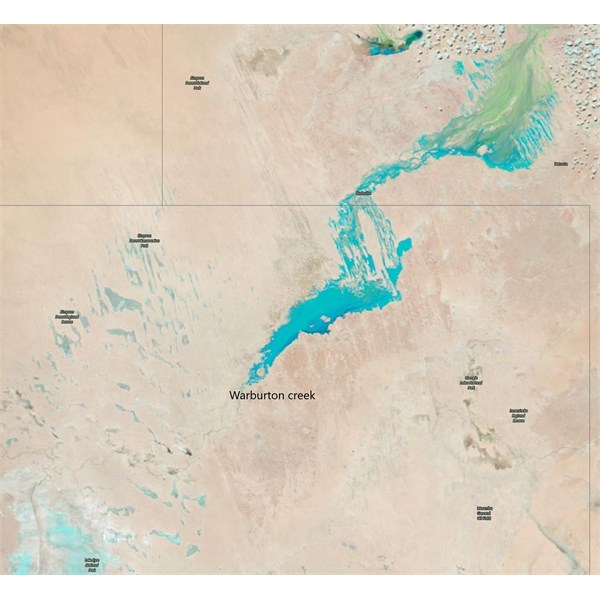
Reply By: Member - Warrie (NSW) - Sunday, Mar 03, 2019 at 14:37
Sunday, Mar 03, 2019 at 14:37
The sat pic also shows that Eyre
Creek is now below
Bedourie and filling
Lake Machattie and two others. It does not seem to be flowing any further south. So a QAA line crossing should be OK and in fact could be done in just 12 more days as the Simpson is reopened on the 15th. That's if you'd want to be there in the heat LOL...... W
AnswerID:
624159
Follow Up By: Bob Y. - Qld - Sunday, Mar 03, 2019 at 16:28
Sunday, Mar 03, 2019 at 16:28
You’re right, Warrie. When the
Hamilton added some weight to the Georgina flow, I was a little concerned, but there is a huge area of very dry floodplain south of
Lake Machattie to Adria Downs, that will further deplete the Eyre Ck flow.
Seems that flies may be the only worry for the Simpson’s “early travellers”. Temps have been down to high 30’s to low 40’s. Not too bad if that’s the only time one can travel?
Looking good for late May!
Bob
FollowupID:
897567
Follow Up By: Teraa - Sunday, Mar 03, 2019 at 17:12
Sunday, Mar 03, 2019 at 17:12
If travelling in
the desert this year be wary of the tracks very dry very soft, the only thing wet is the
creek.
FollowupID:
897569
Reply By: Bob Y. - Qld - Sunday, Mar 10, 2019 at 12:52
Sunday, Mar 10, 2019 at 12:52
Talking to a mate this morning, and he had some current info on Eyre Ck.
Following the daily NASA sat images, the
water appears to have stalled in
the lake system West of
Lake Machattie, over the past week or so. However, the
water has started running into Cowarie
waterhole, just through the Glengyle/Adria Downs
boundary, a few days ago.
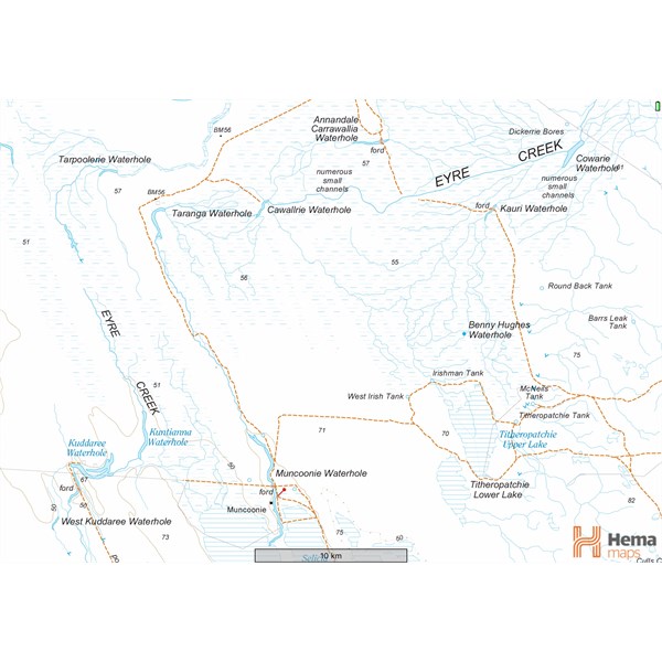
Topo Map-Eyre Creek, on Adria Downs.
It was suggested that the
water would take another week to reach Muncoonie
waterhole, where the Adria
homestead is situated. Whether there will be enough
water to reach the QAA Line is unknown, but at this stage I’d suggest it’s highly unlikely, or may only be a negligible amount.
Bob.
AnswerID:
624345
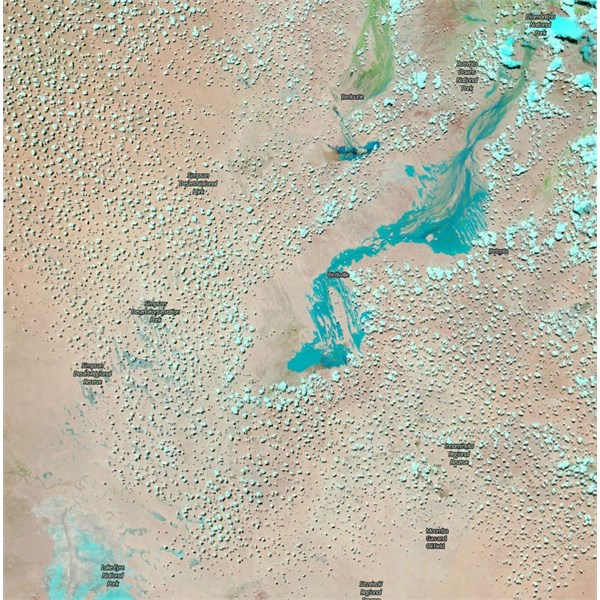
Follow Up By: Teraa - Sunday, Mar 10, 2019 at 15:34
Sunday, Mar 10, 2019 at 15:34
It’s very dry country out there but they the darker colour
water the deeper it is, the
water often stalls out that way takes a bit to get it all the way.
Sat image
It’s
well and truly into the
Warburton 2 weeks ahead of usual rate going about 30 km in 12 hours
FollowupID:
897817
Follow Up By: Bob Y. - Qld - Sunday, Mar 10, 2019 at 19:06
Sunday, Mar 10, 2019 at 19:06
Yes Teraa, we were also talking about the speed of this flood this morning too. Compared it to the ‘99 flood which scoured clay pans and any other ridge country that was flooded. Falls of up to 15” over a day or two, around the Middleton area, got the channels running at full noise.
Bob
FollowupID:
897820