Recording trip details on a map
Submitted: Wednesday, Aug 21, 2019 at 13:01
ThreadID:
138965
Views:
5147
Replies:
3
FollowUps:
6
This Thread has been Archived
Member - John
G'day, having been advised about the search function, not sure if I am using the right words or not but can not find anything. I wish to have a map of Oz with my trip details on it, not tracking as such, as I visited a lot of
places before I got
my SPOT tracker. I wish to plot old trips and
places visited, also it has to work on a laptop not a smart phone. Has anybody got such a program that is easy and user friendly. TIA.
Reply By: Member - Stephen L (Clare SA) - Wednesday, Aug 21, 2019 at 14:07
Wednesday, Aug 21, 2019 at 14:07
Hi
John
I use and highly recommend OziExplorer.
With your maps loaded, you can then see where you want to go and where you have been and great for trip planning.
If you connect it with a GPS, either, Bluetooth, GPS mouse, hand held or what ever, it will record your travels and give you real time mapping as you drive and then you can do many things after that.
You will no doubt get lots of answers, but for me, OziExplorer will not let you down and I have used it out in the field for around 19 years.
Cheers
Stephen
AnswerID:
627363
Follow Up By: Member - John - Wednesday, Aug 21, 2019 at 15:00
Wednesday, Aug 21, 2019 at 15:00
Stephen, wanting to plot
places visited in the past, use SPOT to track current trips, wanting to put all the trips on one map, the map attached is from a app called Trackmytrip, but only works on smart phones, which I don't have.

trakmytrip map
FollowupID:
901333
Follow Up By: Member - Stephen L (Clare SA) - Wednesday, Aug 21, 2019 at 15:24
Wednesday, Aug 21, 2019 at 15:24
John
OziExplorer will do everything you want and a lot more.
I always save every track that we drive, and any important waypoints along the way.
The only trouble with SPOT (yes I know what they are and also use a SPOT 3)
is that the data is only recorded every 5 minutes in my case. When you look at the data that it collects, either on SPOTWALLA or on
the SPOT page, you never get nice clear lines on a map.
The image below is from OziExplorer with the EOTOPO 144k map loaded. The blue lines (this colour I selected, but you can customise what ever colour you want) are the actual path that I drove and recorded by OziExplorer and all those yellow squares with numbers are the waypoints that I recorded.
The area is around the
Oodnadatta Track area and
Coober Pedy. when you go in at 100%, you will see even more data.
So from these images, you will not get any better than this type of track recording.
Cheers
Stephen

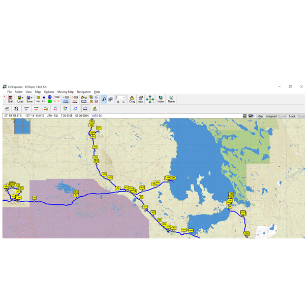
OziExplorer at only 5%

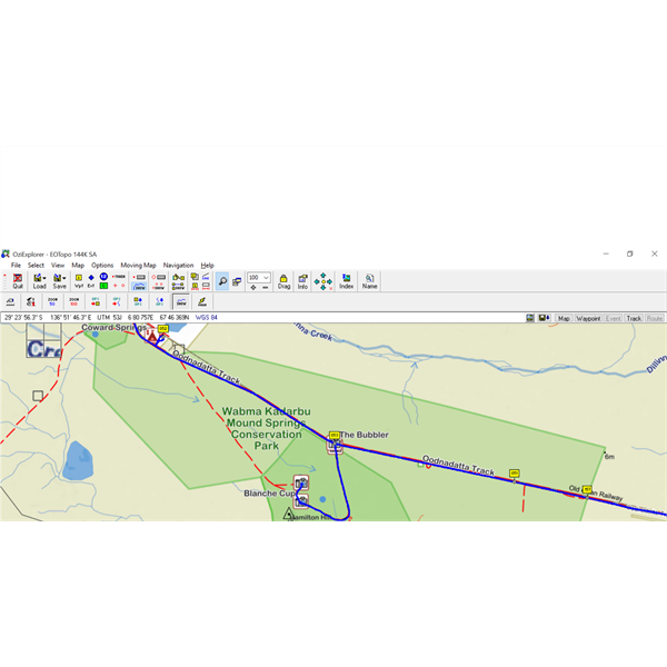
Same map, same data, but at 100%
FollowupID:
901334