Thursday, Apr 09, 2020 at 14:48
DOH!!
Thought I'd edited that off lol.
Correctamundo Barry. Thought we might as
well make it as interactive as possible given we're probably largely stuck at home.
The
graves are located at
Mount Winter in the
Cleland Hills.
I've added a bit from my journals from our 2014 expedition with
well known
Alice Springs historian Dick Kimber. One of the conditions of our permit was that we undertook some
clearing and maintenance of the
grave sites for the Haasts
Bluff elders.
Mount Winter first appears on W H Tietken's plan of exploration in 1890 in his "Cleland Hills" and is believed to originate from Ernest Giles 1873-4 journey and be named after William Winter of Stanhope, Victoria, and later of Rocklands Station near
Camooweal, Queensland. Winter subscribed (financed) Giles exploration. The Luritja name for the area has always been ‘Puritjarra’ which simply means “shadow on
the rock”.
Nearby, in the shadow of this remarkable place lie the
graves of a father and son here who died in 1929. At that time a harsh drought was forcing
the desert people out of the country and into Hermansberg. Reaching Puritjarra, the old man was simply too weak to continue on and his son refused to leave him. They died together and were interred near each other with the massive bulk of Puritjarra to watch over them.
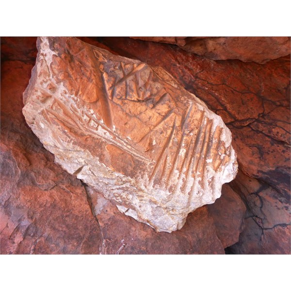
The number of millstones or grindstones about the place is simply incredible and you have to be very careful not to drive over them. Cautiously moving our way through this delicate area, we retreated to the dunes to the east of the Mount and set up
camp behind a belt of mulga. We can hardly wait to explore this fascinating area. We climbed to the top of a nearby dune at dusk to photograph the sunset.
and the next day;
Our first mission of the day was to clean up the areas surrounding the two
grave sites which we cleared of scrub and then swept clean with native brush. Returning to the vehicles, we packed our cameras and headed into the canyon. On the northern side, a high, ridge runs along until it meets the rocky walls of the Range. On the sandy valley floor, a
creek bed winds it’s way out of
the gorge, the flow of
water exposing the rocky nature of the underlying soil.
Of immediate impact were the sheer number of grindstones lying about the area. It was simply amazing. In one area I stood and within 10 square metres, counted more than a dozen grind stones intact with the remnants of many more broken implements lying about. It seemed that every rock you turned had a grinding groove in it, on one side or both. Dick informed us that many of the Grindstones found in collections or front doorsteps around
Alice Springs had been “souvenired" from this area by the less scrupulous travellers from the 1930’s onwards.
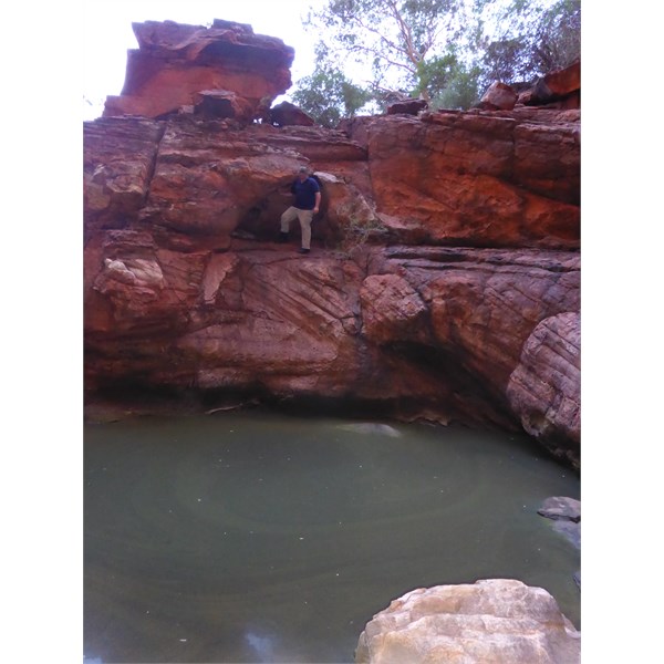
As we approached the end of
the gorge, the sand gave way to a slope of huge, rough boulders. We had to scramble over this jumble of room sized rocks and push our way through scrubby thickets finally reaching a fine pool of
water. Deep in shadow, the dark, cool climate promoted some very different types of vegetation including vines, mosses and lichens. The sheer rock walls towered a hundred metres above us and it would have been most impressive to witness
water flowing over this long drop into
the pool below.
On flat surfaces and in caverns surrounding
the pool we found rocks thick with carved ‘rain lines’, grooves worn into the rocks as part of a rain making ceremony. Together with Scott I climbed up the walls above
the pool to investigate larger caverns where we found softer substrate weathered in remarkable honey comb patterns. From the edge of
the gorge, we gained a remarkable view back along the valley and onto the plains to the east. Carefully picking our way down from the
vantage point, we joined the group and retraced our steps back along the valley to
camp. A spot of lunch and we were on our way north west into the
Cleland Hills.
The
Cleland Hills are a low, western outlier of the
George Gill Range and are surrounded by sand plains and dune fields in the predominantly flat landscape of the
Great Sandy Desert. The Hills are mostly composed of Mereenie
sandstone and hold
water that supports plant species with restricted ranges. The hills support open-woodland with an undergrowth of spinifex grassland.
Driving along the northern edge of this range, the geological history of the area is written deeply in the weathered
sandstone strata. In this area, the
sandstone takes a finely banded form in conical structures not dissimilar to that found in Purnululu (The Bungles) of WA. Weathering of the northern ridges has resulted in large caverns, many of which were used as a place of regular habitation by the nomadic desert people. One of the largest is also referred to as ‘Puritjarra’ and set the archeological and anthropological record of the red centre on its head with discoveries showing regular habitation of the
cavern for a period of 35,000 years. It is also a place that Dick played a significant part in the rediscovery of in the 1980’s.
Puritjarra was first discovered by Europeans in a 1969 expedition to the
Cleland Hills by Robert Edwards, curator of anthropology at the South Australian Museum. Edwards had found the place on foot after the radiator had boiled on his Land Rover, in remote country near the
Cleland Hills. He was still some distance from his destination at Thomas Reservoir (Alalya), where he was taking a party to photograph and document deep ancient rock
engravings. While waiting for the radiator to cool, Tjukadai, Edwards’ guide from Haasts
Bluff, took a walk towards Mt Winter. He returned with news of a rock shelter with
cave paintings:
“We found it was huge — two hundred feet long and sixty feet high … Numerous ochre paintings were around the wall in red, white, yellow and black. There were simple hand stencils, hand prints, bird tracks, kangaroo tracks, circles and snakelike designs. Then, delightedly, we came upon ancient
engravings ... But more precious, the floor of the main
cave was covered with pieces of charcoal, and a small test pit showed many feet of accumulated occupation deposit”.
Excited by the discovery, but short of
water and time, Edwards and his party had been forced to move on to reach Murantji
rock hole. Edwards never returned.
When the archaeologist Mike Smith began his work in Central Australia in the 1980s, he and his colleagues had evidence for people dwelling in the Central Australian deserts up to 3000 years ago. Puritjarra radically changed this. Smith grabbed at a chance opportunity and a permit to travel to Thomas Reservoir in September 1986. On the ground, with aerial photographs in hand, he begged a few hours to scout the Mt Winter area on foot. His mate, Dick Kimber, went south.
Within half an hour Smith struck the Puritjarra rock shelter, one of the biggest he had seen. It was a veritable gallery of rock art and it had an undisturbed earthen floor. The artifacts Smith dug from the site showed dates of 35,000 years, that is penetrating
well back into the Ice Age. This is a very long history of dwelling in a place where it is believed the current arid environment has existed for the past 100,000 years, conditions that made it difficult for people to find
water, food and shelter. Much of
the desert country was believed to have been empty of human habitation for between 10-15 thousand years until the retreat of the last ice age.
With Dick’s intimate knowledge of
the desert people, the Puritjarra area, Smiths work and the cultural significance and meaning of much of
the rock art, we were indeed fortunate and made our visit incredibly special. Dick was able to provide the stories of the etchings, stencils and art work. We listened with wrapped attention as he spoke of the emu dreaming which certainly put a lot of
the rock carvings into perspective for us. Puritjarra is one of the few
places where the hand stencils of children can be found adorning the gallery, much of the art being between 200 and 4700 years old.
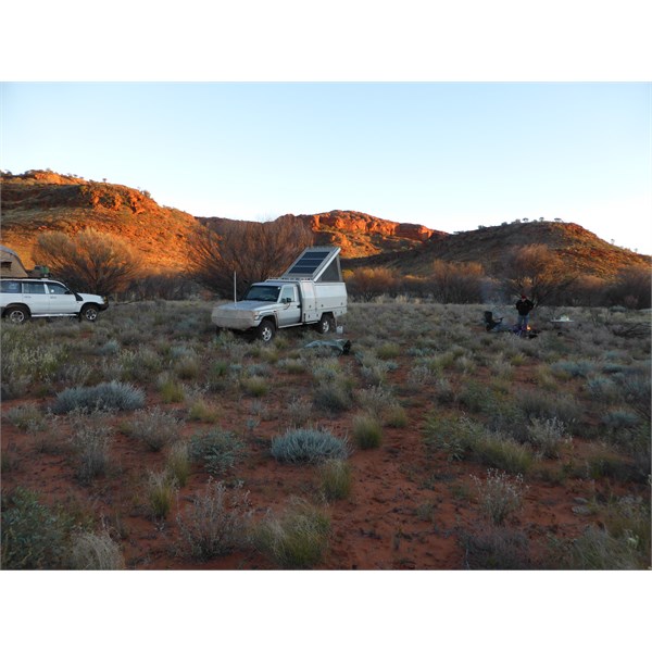
Mt Winter - a brisk morning
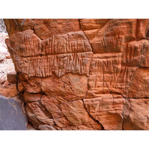
Rain marker grooves
Pool at the end of the gorge
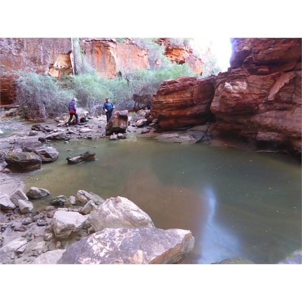
Pool
Grooves
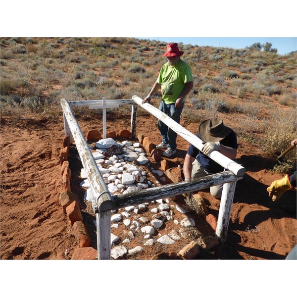
Dick at the graves

Grinder

Dick at Puritjarra
FollowupID:
906788