Map of current road closures in Qld?
Submitted: Monday, Feb 28, 2022 at 09:04
ThreadID:
143312
Views:
25611
Replies:
6
FollowUps:
6
This Thread has been Archived
Member - John
Good morning, has anybody a link to a user friendly site with a MAP of current road closures in S/E Qld? I have looked at many sites, a lot have a list, good if you are a local, RACQ site shows 44 road closures and when clicked on shows a list, Qld Traffic is a useless site. Thanks in advance.
PS, just found one
Flood road closures
Reply By: Genny - Monday, Feb 28, 2022 at 09:37
Monday, Feb 28, 2022 at 09:37
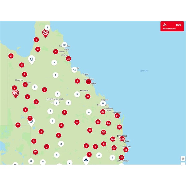
RACQ Interactive map
AnswerID:
639652
Follow Up By: Member - John - Monday, Feb 28, 2022 at 09:49
Monday, Feb 28, 2022 at 09:49
Thanks Genny, tried that, gives you speed cameras etc, but when I click on the road closures tab, it gives you a list, not very useful unless you are a local. Thanks for replying.
FollowupID:
918721
Follow Up By: Member - Boobook - Monday, Feb 28, 2022 at 10:15
Monday, Feb 28, 2022 at 10:15
Strange John. That loink shows a map with all kinds of road closures. When I click on a closure it gives details of the type. the map section of road affected and estimated repair time. Very useful.
Maybe try a different browser.
FollowupID:
918722
Follow Up By: Member - John - Monday, Feb 28, 2022 at 10:42
Monday, Feb 28, 2022 at 10:42
Genny, running Google Chrome, have no idea why I am seeing different to you? I am in
Ballina at present and will be until roads are open, maybe two or three days, if it wasn't for a new great grand daughter in Hervey Bay we would be heading South again. Cheers.
FollowupID:
918724
Follow Up By: Genny - Monday, Feb 28, 2022 at 10:44
Monday, Feb 28, 2022 at 10:44
Zoom in/out on the map, pick your route, click on the individual icons along your route to see whats what. Sometimes you'll need to zoom in close, as what appears to be a closure on your route may be on a close side path.
RoadClosures
FollowupID:
918725
Follow Up By: Genny - Monday, Feb 28, 2022 at 11:00
Monday, Feb 28, 2022 at 11:00
Ballina to Hervey Bay most direct route definitely closed several locations, and probably all reasonable alternates. Put your feet up.
FollowupID:
918726
Follow Up By: Member - John - Monday, Feb 28, 2022 at 11:03
Monday, Feb 28, 2022 at 11:03
Yep, that is the plan, cheers, John
FollowupID:
918727
Reply By: Nomadic Navara - Monday, Feb 28, 2022 at 11:51
Monday, Feb 28, 2022 at 11:51
I use the main roads one -
Qld Traffic - I find it better for my use - However, it's a bit slow updating on my FF at present.
AnswerID:
639654
Reply By: Member - Core420 - Monday, Feb 28, 2022 at 15:18
Monday, Feb 28, 2022 at 15:18
Google maps
AnswerID:
639656
Reply By: Hoyks - Monday, Feb 28, 2022 at 16:20
Monday, Feb 28, 2022 at 16:20
Unless you absolutely have to travel, then I'd put it off. My RACQ page shows 750 road closures and is a sea of red pins for SE QLD.
I was out working with the RFS for the SES all yesterday and none of the online maps were accurate as we were closing roads as the waters rose. Even 4 hours later some of the roads I'd seen under 1m of
water were still shown as open on various websites as no one was keeping up with the updates.
The online maps are hooked into the official road closures, so if you plan a trip they should steer you around them, but again, only once things settle down a bit.
AnswerID:
639658
Reply By: lindsay - Monday, Feb 28, 2022 at 20:51
Monday, Feb 28, 2022 at 20:51
I would not trust their site. Several years ago they had shown the road from
Boulia to
Winton as open so we decided to go that way and about 2 ks out of
Boulia there was
sign that indicated that the road was closed, apparently there was .5 of a metre of
water over the road. We then had a 800 Km detour.
Lindsay
AnswerID:
639664