The way to Blue Waterholes from Canberra
Submitted: Tuesday, Oct 09, 2012 at 14:09
ThreadID:
98449
Views:
8625
Replies:
4
FollowUps:
9
This Thread has been Archived
Member - Rich
Hi,
Am doing some hunting around for ways to get to
Blue Waterholes from
Canberra.
I have found a couple of plots but there does seem to be some issues over locked gates. Also a few of the roads are not named on my map.
Barnetts road seems to be the way to go but my question is do you travel along Brindabella road until
the junction of Nottingham Road, Bridabella road and Barnetts or can you turn left at Bobbys Plain. See pic below
I have 3 alternative
routes so far.
1. The Blue one which turns left at Bobbys Plain and does not go via Barnetts road
2. The
Orange one which goes all the way to
the junction I mentioned above
3. The Purple one is a hybrid of the two above , in that I would turns left at Bobbys Plain like option 1 and then cuts across to Barnetts road
I am not looking for the most challenging route, just an easy drive through the bush
Thanks in advance,
Richard
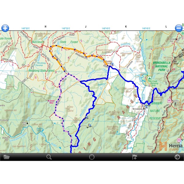
Proposed trip
Reply By: Member - Rich - Tuesday, Oct 09, 2012 at 16:38
Tuesday, Oct 09, 2012 at 16:38
And another variation
In this one I have added the green track which is I think
boundary road and the other leg is Broken Cart.
Any opinions on the best tracks to follow?
Rich
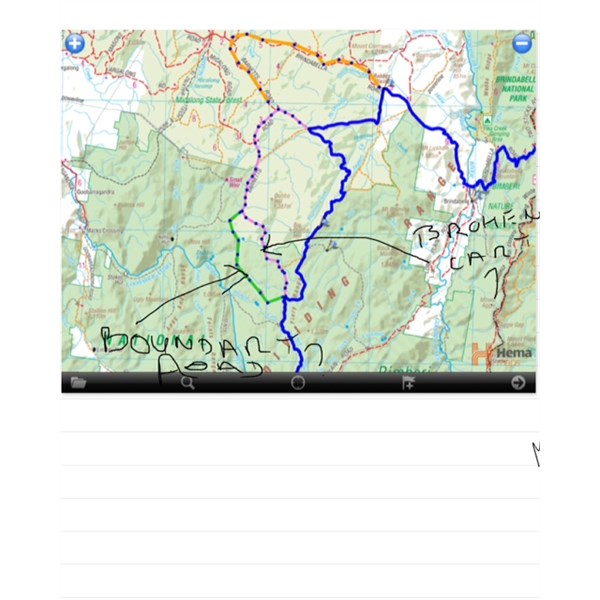
Another variation
AnswerID:
496362
Reply By: Member - Tony (ACT) - Tuesday, Oct 09, 2012 at 16:41
Tuesday, Oct 09, 2012 at 16:41
I,m heading up there tomorrow, and going via your blue track. I also need to check out a couple of
camp sites on the Hume & Hovell track to the north of Brindabella Road
AnswerID:
496363
Follow Up By: Member - Tony (ACT) - Tuesday, Oct 09, 2012 at 16:45
Tuesday, Oct 09, 2012 at 16:45
Opps, I just looked again, part of the blue then follow the power lines, to Barnetts, the onto Broken Cart.
FollowupID:
772056
Follow Up By: Member - Rich - Thursday, Oct 11, 2012 at 16:17
Thursday, Oct 11, 2012 at 16:17
Tony
How did you get on?
Was your route Blue then Powerline to Purple (not coloured on the maps I have included).
The purple includes Barnetts road then runs in to Broken Cart
I note there is supposed to be a
locked gate at
the junction of
Boundary, Broken Cart, which side is it on ?
It is a bit confusing as I have found some roads labelled wrong/different in the maps and plots I have been looking at.
In my maps I think:
Blue is Brindabella -->
Boundary-->Powerlines -->Bramina -->
Boundary
Purple is Bramina --> Barnetts -->Broken Cart
Green is
BoundaryOrange is Brindabella--> Barnetts
Richard
FollowupID:
772157
Follow Up By: Member - Tony (ACT) - Thursday, Oct 11, 2012 at 20:52
Thursday, Oct 11, 2012 at 20:52
Just got back tonight.
Turned down Boundry Rd at the first
sign on Tumut Rd.
Then onto Power Line Road as soon as you come to power lines.
At
the junction of Barnetts Rd I turned right to go to the Hume & Hovell track.
Left onto Micalong Rd at the swamp till back onto Barnets Rd.
Then left onto the start of Broken Cart all the way to
Long Plain rd.
No
sign of any
gate at the Boundry Rd/Broken Cart
junction.
You could follow Barnetts Rd all the way from the Tumut rd, as the power line road can get a bit ugly in parts.
FollowupID:
772190
Follow Up By: Member - Rich - Friday, Oct 12, 2012 at 00:03
Friday, Oct 12, 2012 at 00:03
Tony
I think you have followed the blue turn off Tumut road, then followed Powerlines down to Barnetts road
Just wandering why you went that way. My map shows that the Micalong road runs into Tumut/Brindabella road which runs into Hume & hovel track.
Sounds like a great drive.
Rich
FollowupID:
772206
Follow Up By: Member - Tony (ACT) - Friday, Oct 12, 2012 at 07:53
Friday, Oct 12, 2012 at 07:53
I had all day to get where is was going, so I wanted an interesting drive, and I got that. Now I am snowed in at the farm.
FollowupID:
772214
Follow Up By: Member - Rich - Friday, Oct 12, 2012 at 08:01
Friday, Oct 12, 2012 at 08:01
What!!!!!!!
Snow, been nothing but rain here.
Rich
FollowupID:
772217
Follow Up By: Member - Tony (ACT) - Friday, Oct 12, 2012 at 08:27
Friday, Oct 12, 2012 at 08:27
Yep white stuff all over
.
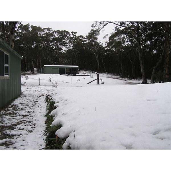
Snow at farm
FollowupID:
772219
Follow Up By: Member - Rich - Friday, Oct 12, 2012 at 08:38
Friday, Oct 12, 2012 at 08:38
WOW!
I had to go out and saw the snow up in the mountains but did not look that heavy.
The weather has all gone to s#$$. This is normally the nicest time of the year.
Lucky you did not do your trip this week.
Rich
FollowupID:
772222
Reply By: Member - Rich - Tuesday, Oct 09, 2012 at 17:05
Tuesday, Oct 09, 2012 at 17:05
Tony,
The blue track was from a plot I found on the web but further reading gave me the impression some of it may be closed.
So I think the track that may be good would be
Blue ,
Orange, Purple, Green then Blue again but reckon some other are OK. (Travel by colors, sounds like a kids game ??).
Let me know which way you go if you can. A mate and I were going to go up for a day trip and do some of the walks around the area.
Last time I went I went via the black top as much as I could. One of the above would be more interesting.
Have a great trip
Rich
AnswerID:
496365
Follow Up By: Member - Tony (ACT) - Tuesday, Oct 09, 2012 at 17:18
Tuesday, Oct 09, 2012 at 17:18
Thats part of what my trip is all about, check out the camps for the Hume & Hovell Track in that section, then down to
Long Plain,
camp in Cooinibil Hut if its wet, then do a bit of fishing in some of the streams and rivers.
FollowupID:
772058
Reply By: Member - willawa - Tuesday, Oct 09, 2012 at 18:06
Tuesday, Oct 09, 2012 at 18:06
Rich
the last time I inquired (Jan/ Feb) there are a couple of locked gates and also a diversion or 2.due to repair work and
washouts. (Hopefully fixed by now)
It may be best to contact National Parks at
Yarrangobilly Caves I found them most helpful re these tracks.
Cheers
Ed
AnswerID:
496369