Channel Country starts where
Submitted: Saturday, Mar 09, 2013 at 08:40
ThreadID:
100981
Views:
3837
Replies:
7
FollowUps:
17
This Thread has been Archived
Robyn R4
Where does "Channel Country" start on the Capricorn Highway?
I travelled the highway from
Rockhampton to
Winton in 2004 and remember being amazed by how far east the
sign was that told us we were entering Channel Country....we drove over a slight crest and yep, it was "as flat as" from there on. I had imagined it to be a lot further west- more towards
Longreach way.
Can anyone enlighten me where that rise in the road is? As far east as
Jericho?
:)
Reply By: Alloy c/t - Saturday, Mar 09, 2013 at 11:19
Saturday, Mar 09, 2013 at 11:19
Western side of the Drummond Range , as you head west from
Emerald and crest the range a large
sign tells you from this point rivers + creeks flow west + south ,, the Channel country ,,,,
AnswerID:
506391
Follow Up By: Robyn R4 - Saturday, Mar 09, 2013 at 12:19
Saturday, Mar 09, 2013 at 12:19
Thank you!
As far east as
Emerald way, eh?!
I remember being surprised by how far east the
sign was, but couldn't remember exactly where...
Thanks again!
:)
FollowupID:
783328
Follow Up By: luxtourer - Saturday, Mar 09, 2013 at 22:53
Saturday, Mar 09, 2013 at 22:53
Don't think so! West of the Drummond Range is the start of the Belyando R, which goes north into the Burdekin. You need to at least cross the Great Dividing Range, so around
Jericho and west.
Cheers, John
FollowupID:
783370
Follow Up By: Member - Ed C (QLD) - Sunday, Mar 10, 2013 at 00:59
Sunday, Mar 10, 2013 at 00:59
luxtourer is on the money
Lake Eyre Basin
:)
| Confucius say.....
"He who lie underneath automobile with tool in hand,
....Not necessarily mechanic!!"Member
My Profile Send Message |
FollowupID:
783374
Follow Up By: Alloy c/t - Tuesday, Mar 12, 2013 at 10:36
Tuesday, Mar 12, 2013 at 10:36
Don't know where you get your maps from Luxtourer but the 'Drummond Range' is part of the "great dividing range" at better than 460mtr above sea level ,,
FollowupID:
783634
Follow Up By: luxtourer - Tuesday, Mar 12, 2013 at 11:12
Tuesday, Mar 12, 2013 at 11:12
Tis you that needs the better maps, Alloy c/t. The Drummond Range splits off the Great Dividing Range (GDR) NE of
Tambo, and heads up towards
Clermont. With the
Denham Range, it separates the Fitzroy R basin from the Burdekin R basin.
I think you will find the
sign you mention just east of
Jericho, where the actual GDR crosses the Capricorn Hwy (as per Ed C's map).
It's true the Drummond Range is the more dramatic of the two range crossings, but part of the GDR it is not.
Cheers, John
FollowupID:
783636
Follow Up By: Alloy c/t - Tuesday, Mar 12, 2013 at 11:57
Tuesday, Mar 12, 2013 at 11:57
As stated , previously ,the
sign is actually WEST of
Emerald just over the Drummond range crest ,
well before
ALPHA let alone JERICO
FollowupID:
783641
Follow Up By: luxtourer - Tuesday, Mar 12, 2013 at 12:14
Tuesday, Mar 12, 2013 at 12:14
Well, if you're going to ignore the evidence of Ed C's map, Rockape's map, and the knowledge of locals, then there's no more to be said, is there?
Cheers, John
FollowupID:
783645
Follow Up By: Alloy c/t - Tuesday, Mar 12, 2013 at 18:27
Tuesday, Mar 12, 2013 at 18:27
Lux , I am a 'local ' of the channel country and drive to
Emerald on a regular basis, I damn
well know where the
sign proclaiming the start of channel country is located, recent rains that we missed out on to our north has now passed us but is still rising in
Longreach ,, from our location to Lake Eyre
water takes 12 mths to get there ,,,
FollowupID:
783684
Follow Up By: Robyn R4 - Tuesday, Mar 12, 2013 at 20:02
Tuesday, Mar 12, 2013 at 20:02
Alloy!
A local!
I knew there'd be a local out there somewhere!
Locals always know, don't they?!
Thanks!
:)
FollowupID:
783692
Follow Up By: Member - Ed C (QLD) - Tuesday, Mar 12, 2013 at 22:08
Tuesday, Mar 12, 2013 at 22:08
Maybe whoever put the
sign there was not a local ;-)
If it's anywhere east of
Alpha, then not only is it misplaced, but it's quite misleading, and obviously highly confusing (to locals and non-locals alike, it would seem)..
As correctly pointed out by luxtourer, east of
Alpha is the headwaters of the Belyando River (and it's tributaries, one of which is
Alpha Creek)..
This is most definitely NOT the "start of the Channel Country"
Belyando River
As already pointed out, just east of
Jericho (Alice River) is where it's at......
:)
| Confucius say.....
"He who lie underneath automobile with tool in hand,
....Not necessarily mechanic!!"Member
My Profile Send Message |
FollowupID:
783718
Follow Up By: Alloy c/t - Wednesday, Mar 13, 2013 at 09:42
Wednesday, Mar 13, 2013 at 09:42
Go to Bom Site ,
Longreach Radar , 512klm composite , "tick" Locations - Range - Topography - Lakes +Major Rivers -River Catchments ,,,,,
FollowupID:
783739
Follow Up By: Member - Ed C (QLD) - Wednesday, Mar 13, 2013 at 11:30
Wednesday, Mar 13, 2013 at 11:30
Yep, did that.. :)
It confirms what luxtourer and I have been saying..
Check this out >>
Fitzroy River Basin
:)
| Confucius say.....
"He who lie underneath automobile with tool in hand,
....Not necessarily mechanic!!"Member
My Profile Send Message |
FollowupID:
783748
Follow Up By: Member - John and Val - Wednesday, Mar 13, 2013 at 14:32
Wednesday, Mar 13, 2013 at 14:32
Just to complicate things there is a Channel Country bio-region -
see link here which is mainly in far SW Qld and is described as follows:
"The Channel Country bioregion is located on the
Queensland, New South Wales (NSW), South Australia
(SA) and Northern Territory (NT) borders (67% of
area in Queensland, 17% in SA, 8% in the NT and
8% in NSW)."
It would seem that it rather depends on whether you are taking a catchment/watershed approach, a bioregion approach or an "on the ground" approach as to where various boundaries of the channel country might be.
Cheers,
Val
| J and V
"Not everything that can be counted counts, and not everything that counts can be counted."
- Albert Einstein
Lifetime Member
My Profile My Blog Send Message |
FollowupID:
783755
Follow Up By: luxtourer - Wednesday, Mar 27, 2013 at 22:12
Wednesday, Mar 27, 2013 at 22:12
Hi all
Bob Y has now kindly posted pictures of the signs in his 2nd post below.
Thanks for your support, Ed.
Cheers, John
FollowupID:
785004
Reply By: Member - John and Val - Saturday, Mar 09, 2013 at 12:19
Saturday, Mar 09, 2013 at 12:19
If you have a look on Google earth you can clearly see braided channels in some of the
water courses feeding into (and west of)
Lake Maraboon, so that
sign is
well placed. The channelling or braiding becomes more pronounced as the rivers get further out onto the plains.
Cheers,
Val
| J and V
"Not everything that can be counted counts, and not everything that counts can be counted."
- Albert Einstein
Lifetime Member
My Profile My Blog Send Message |
AnswerID:
506399
Reply By: Rockape - Saturday, Mar 09, 2013 at 12:29
Saturday, Mar 09, 2013 at 12:29
Have a look
HERE
AnswerID:
506400
Reply By: Member - Warrie (NSW) - Saturday, Mar 09, 2013 at 13:12
Saturday, Mar 09, 2013 at 13:12
Yes it's along way from the Drummond Range to
Innamincka but it all ends up in
Cooper Creek. After a dry "wet" some flow has reached
Nappa Merrie and the causeway at
Innamincka. See here
Cooper at Cullyyamurra
Cheers, Warrie
AnswerID:
506405
Follow Up By: Robyn R4 - Saturday, Mar 09, 2013 at 20:27
Saturday, Mar 09, 2013 at 20:27
That "magic point" that we passed near
Emerald was "connected" to the
Cullyamurra Waterhole? We camped at that
waterhole last September! Wow!
I lived on the Murray for years and knew that there were a lot of NSW/Qld rivers that flowed down to us, but I hadn't sat down to connect the rivers in western Qld/SA... Isn't Channel Country mind-boggling?!
Thanks for more input than I could have imagined.
Robyn :)
PS: Who's had a dry wet?! Hasn't stopped raining for months up here! My mould is growing mould!!
FollowupID:
783355
Reply By: Nomadic Navara - Thursday, Mar 14, 2013 at 00:30
Thursday, Mar 14, 2013 at 00:30
Who's idea of the Channel Country are you talking about?
There are a lot of different "extensions" of regions done by tourist bodies to increase their profits. For example take the Great Ocean Road. My idea of it is it really is just the bit dug out of the hillside by the ex-diggers from the first world war (the bit from Eastern View to
Apollo Bay.) Others have extended it bit by bit and now the tourist mob reckon it goes from
Geelong to Mt Gambier.
In like manner the Channel Country has been "stretched." To the old-timers it was the area around the Georgina River, Eyre
Creek,
Warburton Creek,
Coopers Creek and the Diamantina River.
See this link. The old-timers did not include the tributaries like the
Thomson River as it was a single stream and did not form into channels like in the true channel country.
AnswerID:
506754
Reply By: Bob Y. - Qld - Thursday, Mar 14, 2013 at 18:09
Thursday, Mar 14, 2013 at 18:09
I think that some of you have your terminology wrong!
The
sign that Robyn is referring to is
the Lake Eyre Basin
sign that states "You are now entering
the Lake Eyre Basin -
Cooper Creek Catchment"
Then there is the great Dividing Range
sign, on an insignificent ridge on the Capricorn highway. This
sign is, though i'm having a senior moment here, just east of
Jericho.
Driving down that way on Sunday, so I'll be able to check
The "real" Channel Country probably starts south of Urandangie,
Winton and
Windorah.
Bob.
.
AnswerID:
506787
Follow Up By: luxtourer - Friday, Mar 15, 2013 at 13:50
Friday, Mar 15, 2013 at 13:50
Hi Bob
Be good if you do have a chance to sort out the locations of the signs. Let us know.
Cheers, John
FollowupID:
783960
Reply By: Bob Y. - Qld - Tuesday, Mar 26, 2013 at 15:21
Tuesday, Mar 26, 2013 at 15:21
Robyn,
Apologies for the late posting of these photos, but haven't been near this computer for sometime.
I was sleeping when we travelled this part of the highway, but the Driver/Cook/Mate/....oh, err the Wife had strict instructions to stop here for a kodak moment. I didn't check the distance but it's about 40 clicks to
Alpha, to the EAST of this ridge.
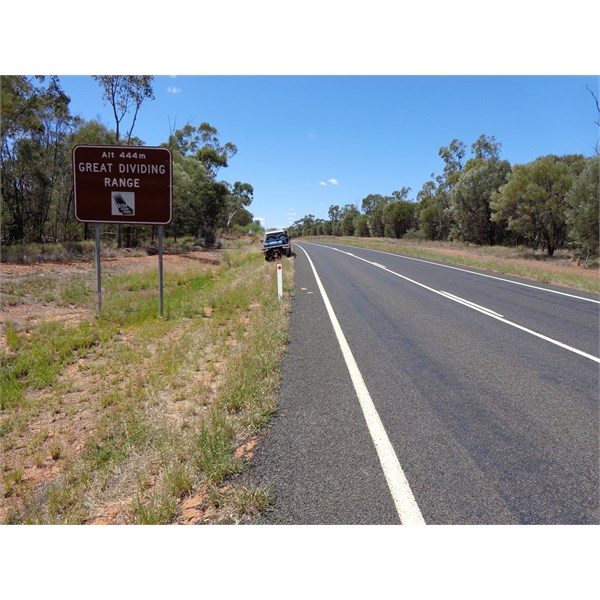
Looking east towards Alpha.
l
The Lake Eyre Basin
sign is not far from the other
sign, and I note it says "Cooper's Ck", not Cooper Ck, as I said in my reply above. I stand corrected!!!
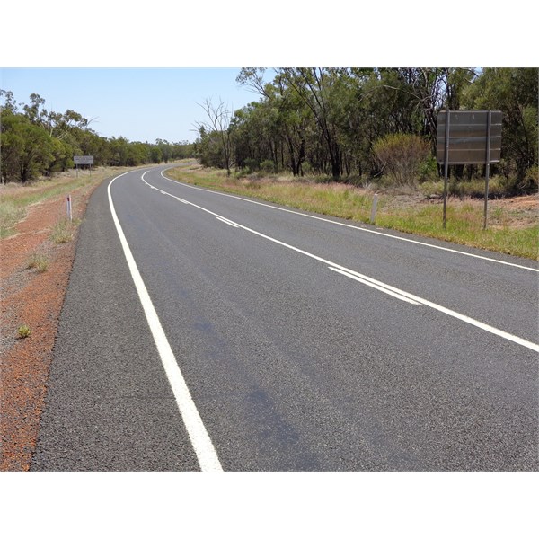
Looking west, towards Jericho.
Looks like some of us drive a little too quickly, and maybe don't take in the surroundings as
well as we should. Guilty of that myself, on numerous occasions too :-)
Bob.
AnswerID:
507617
Follow Up By: Robyn R4 - Tuesday, Mar 26, 2013 at 19:48
Tuesday, Mar 26, 2013 at 19:48
Thanks Bob!
If someone was to ask me about a
sign in my neck of the woods I don't think I'd be able to be too exact either...!
Thank the boss ("She-who-knows-best") for stopping!
:)
FollowupID:
784937