Argyle Downs is a pastoral lease and cattle station located about 120 kilometres south east of
Kununurra in the
Kimberley region near the border of Western Australia and Northern Territory. It is operated by the Consolidated Pastoral Company.
The station occupies an area of 1,000 square kilometres and is a mix of black soil plains and red basalt country with the
Ord River and
Lake Argyle situated on the
western boundary. Currently the property annually turns off 7,500 head of cattle for live export to the south East Asia market. Stock horses are also bred and raised on the property for use on other stations.
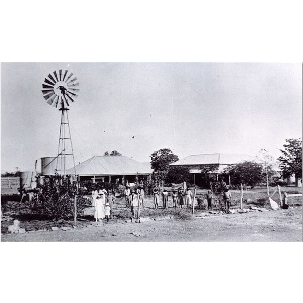
Argyle Station 1921
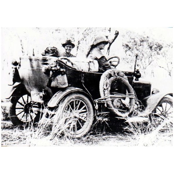
Mrs M.P Durack on road between Ivanhoe & Argyle Station
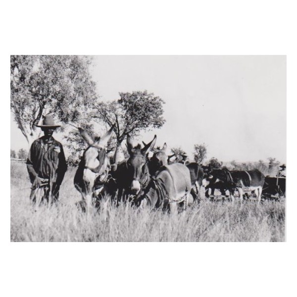
Donkey Team at Argyle Station
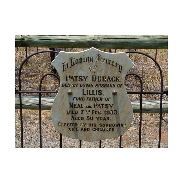
Headstone for Patsy Durack - Argyle Homestead
The area was settled by Patrick and his brother Michael Durack in 1882 who arrived in the area after trekking across the north of the continent from their property on
Coopers Creek in Queensland where they left from in 1879 along with 7250 breeding cattle and 200 horses. The 3000 mile journey of cattle to stock Argyle Downs and Ivanhoe Station is the longest of its type ever recorded.
The Duracks exported the cattle from the station through the port of
Wyndham to markets as fas as South Africa and North America.
The
homestead was constructed in 1895 by the Durack family and was renowned as one of the main social gathering
places in the east
Kimberley. Built from
limestone blocks and mortar made from crushed
termite mounds the
homestead had to be dismantled to make way for
Lake Argyle in the 1970s. The
homestead was reopened in 1979 and now acts as a museum in its present location along the shore of
the lake.
By 1901 the station along with Newry and Auvergne was carrying about 45,000 head of cattle. 2,606 cattle were taken from Argyle Downs and moved overland to Queensland in 1911. During the journey many of the drovers suffered from fever including Thomas Stafford who died as a result of his illness.
A medical emergency at the station in 1944 resulted in a mercy flight being sent from
Perth. Tragically the RAAF plane crashed into the ocean killing all five members of the flight.
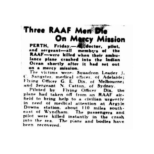
Three RAAF Men Die On Mercy Mission 2 September 1944
In 1951 over 700 bullocks from the Station were sold and transported to
Wyndham for slaughter at the meatworks.
A sizable proportion of the lease was resumed by the Government in the 1950s for the
Ord River Irrigation Scheme.
Lake Argyle is Australia's largest artificial lake by volume. It is part of the
Ord River Irrigation Scheme and is located near the East
Kimberley (Western Australia) town of
Kununurra.
The lake flooded large parts of the Shire of
Wyndham-East
Kimberley on the
Kimberley Plateau about eighty kilometres inland from the
Joseph Bonaparte Gulf, close to the border with the Northern Territory.
The primary inflow is the
Ord River, while the Bow River and many other smaller creeks also flow into the dam.
The lake is a DIWA-listed wetland as it is the largest lake in northern Australia and an excellent example of a man-made lake. Additionally
Lake Argyle, along with Lake
Kununurra, are recognised as a Ramsar protected wetlands and were listed in 1990 as Australian Site Number 32

Dam wall and Lake
The construction of the
Ord River Dam was completed in 1971 by the American Dravo Corporation. The dam was officially opened the following year. The dam is 335 metres long, and 98 metres high. The earth-fill only dam wall at
Lake Argyle is the most efficient dam in Australia in terms of the ratio of the size of the dam wall to the amount of
water stored.
The lake was named after the property it partly submerged, Argyle Downs.
In 1996, the spillway wall was raised by 6 metres, which doubled the dam's capacity.[5] Sediment flowing into the dam caused concerns in the mid 1990s that the dam's capacity could be dramatically reduced. By 2006 continual regeneration of the upper Ord catchment appeared to have reduced the amount of sediment inflow
Lake Argyle normally has a surface area of about 1,000 square kilometres. The storage capacity, to the top of the spillway is 10,763,000 megalitres.
The lake filled to capacity in 1973, and the spillway flowed until 1984.
Lake Argyle's usual storage volume is 5,797,000 megalitres, making it the largest reservoir in Australia. The combined Lake Gordon/Lake Pedder system in Tasmania is larger but is two dams connected by a canal. At maximum flood level,
the lake would hold 35 million megalitres of
water and cover a surface area of 2,072 square kilometres.
Lake Argyle, together with Lake
Kununurra, is part of the
Ord River Irrigation Scheme. There are currently some 150 square kilometres of farmland under irrigation in the East Kimberly region. The original plan was for dam
water to irrigate rice crop for export to China.
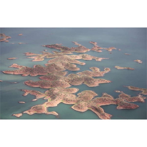
Tops of the hills have formed islands
However these plans were scuttled as waterfowl, particularly magpie geese ate rice shoots quicker than they could be planted. Other crops are now grown, but
Lake Argyle still remains Australia's most under-utilized
The damming of the
Ord River has caused major changes to the environment.[citation needed] Flows to the
Ord River have been severely reduced. Within
Lake Argyle itself a thriving new eco-system has developed.
The lake is recognised as an important wetland area under the Ramsar Convention; with Lake
Kununurra it forms the Lakes Argyle and
Kununurra Ramsar Site.
The lake is now home to 26 species of native fish and a
population of freshwater crocodiles currently estimated at some 25,000. Fish species that are present in
Lake Argyle include barramundi, southern saratoga, archer fish, forktail cat fish, mouth almighty, long tom, bony bream and sleepy cod. While the official website states that only incidentally a saltwater crocodile is found, other experts disagree. Everyone assumes that
Lake Argyle has no saltwater crocodiles,
well there's a few in there as the most recent survey confirmed, he said. "A lot of people go barramundi fishing in those areas and if you're not paying attention you're going to get a shock. Dr Mawson listed fishing in knee-deep
water, cleaning fish close to the shore at dark and letting dogs and children play unattended at a river as prime activities where people were putting themselves at risk.
Cane toads reached the dam in late 2008, mostly via traveling along the Victoria Highway, with numbers rising significantly during the 2009 summer.