Todays SHP is again posted from Nürnberg, Germany....Next week will be
Sydney
The concept and design of the Stuart Highway began in 1870 by the South Australian Government. Between 1911 and 1978 the Commonwealth and various state government departments utilised in house resources and consultants to continue development. The Northern Territory Government took responsibility for construction from 1978.
The highway began in 1870 as a supply track along the Overland Telegraph and over 130 years later, it is now the Stuart Highway as we know it today.
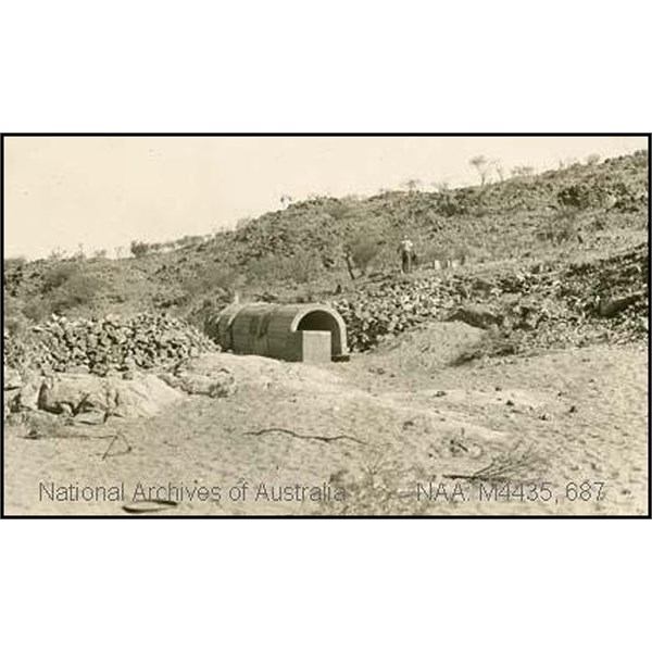
Construction of Stuart Highway at Charles Creek, north of Alice Springs - culvert being built
The Stuart Highway North connects
Alice Springs with
Darwin via numerous small towns and the two major centres of
Tennant Creek and
Katherine. The explorer John Mc Douall Stuart, on his third attempt, crossed the continent of Australia from
Port Augusta to the north coast arriving 20
miles east of the mouth of the
Adelaide River on 24 July 1862. Stuart’s Reports spoke highly of the potential of the country that he had traversed and based on Stuart’s advice South Australia had the land to its north excised and on 6 July 1863 the Northern Territory became the responsibility of South Australia14. In 1871 the
Overland Telegraph line was constructed linking
Port Augusta and the southern states with the recently established settlement of Palmerston. The undersea cable connecting Australia to the world through Java came ashore at Palmerston on Port
Darwin. The Overland Telegraph followed the route taken by Stuart for a substantial proportion of its 1765-mile length.
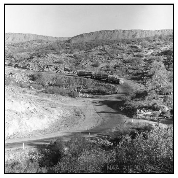
A road train heading north from Alice Springs on the Stuart Highway to pick up cattle, 1970
The alignment of the telegraph was kept cleared of trees, maintenance and resupply of stores for the telegraphers at the Repeater Stations, meant that traffic along the route was ongoing and “The Overland” became established. Any Travellers, Drovers, Adventurers & Overlanders crossing the continent followed the
Overland Telegraph Line further adding to the development of the road.
The discovery of gold at
Tennant Creek in 1934 lead to increased traffic from
Alice Springs. The road was upgraded to partially gravelled and partially formed in response to the last Australian gold rush. Over the next six years the road north of
Tennant Creek was improved, new road alignments pegged and reconnaissance surveys carried out through to Birdum.
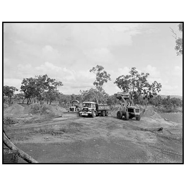
A roadmaking plant on the 956 mile Stuart Highway, near Katherine, NT
The desire of the South Australian government to construct a transcontinental railway lead to railways being constructed north from
Adelaide to
Port Augusta in 1878, to
Marree in1884,
Oodnadatta in1891 and
Alice Springs in 1929. South from
Darwin a railway was built to
Pine Creek in 1889, to Emungalan, on the northern bank of the
Katherine River, in 1917 and to Birdum in 1929. The alignment of the railways were selected on an engineering basis therefore in the north the railway alignment was different from that of the telegraph. New telephony circuits when installed were constructed along the railway. Past the railheads the track along the telegraph alignment continued to be the route followed by those travelling north or south.
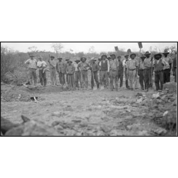
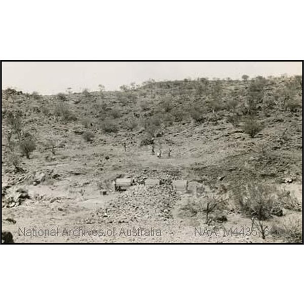
Road Gang probably working on Stuart Highway through hills north of Alice Springs
The alignment of the telegraph was kept cleared of trees, maintenance and resupply of stores for the telegraphers at the Repeater Stations, meant that traffic along the route was ongoing and “The Overland” became established. Any Travellers, Drovers, Adventurers & Overlanders crossing the continent followed the
Overland Telegraph Line further adding to the development of the road.
The discovery of gold at
Tennant Creek in 1934 lead to increased traffic from
Alice Springs. The road was upgraded to partially gravelled and partially formed in response to the last Australian gold rush. Over the next six years the road north of
Tennant Creek was improved, new road alignments pegged and reconnaissance surveys carried out through to Birdum.
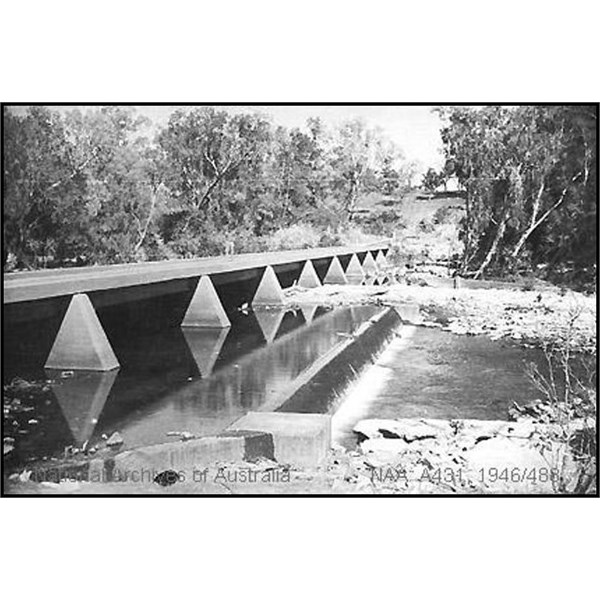
The low level bridge, Katherine 1945
The desire of the South Australian government to construct a transcontinental railway lead to railways being constructed north from
Adelaide to
Port Augusta in 1878, to
Marree in1884,
Oodnadatta in1891 and
Alice Springs in 1929. South from
Darwin a railway was built to
Pine Creek in 1889, to Emungalan, on the northern bank of the
Katherine River, in 1917 and to Birdum in 1929. The alignment of the railways were selected on an engineering basis therefore in the north the railway alignment was different from that of the telegraph. New telephony circuits when installed were constructed along the railway. Past the railheads the track along the telegraph alignment continued to be the route followed by those travelling north or south.
Mrs Aeneas “Jeannie” Gunn in her book “We of the Never Never” details a trip in 1902 from Palmerston to Elsey Station. She travelled by train to
Pine Creek and then by horse and buck-board to Elsey
Homestead near Warloch Ponds. Chapter 5 of her book contains a description of the “Transcontinental Route”. The book contains a photograph of “The Overland in 1900” a very early image of “The Track”. She also describes the alternatives of crossing the flooded Fergusson in the “HMS Immovable” a half-ton iron punt provided by the government or “the wire” a flying fox.
The first crossing of the continent south to north by a horseless carriage was by Henry Dutton and Murray Aunger. In 1907 they made their first unsuccessful attempt in a
Talbot. They were successful on August 20 1908 when they reached
Darwin in a second “especially imported”
Talbot. The “2100 mile trip principally following the telegraph line” took 42 days.
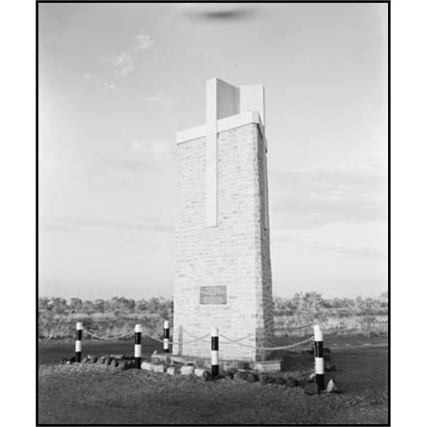
Flynn Memorial, at 3 Ways, Stuart Highway, NT
The establishment of pastoral properties and the need to get cattle to markets lead to the development of a network of stock
routes across the Territory. The North South stock route followed the telegraph line over most of its length.
On February 12 1907 the Commonwealth Government reached an agreement with the South Australian Government on the future administration of the Northern Territory. This resulted in the Commonwealth of Australia taking over responsibility for the Northern Territory on 1 January 1911. The Commonwealth carried out surveys of the major Northern Territory roads and stock
routes and performed upgrading works and made improvements on the road and stock
routes.
The introduction of air
services from Australia to Asia and Europe in 1930 resulted in the development of
Daly Waters as a major airport and refuelling stop where through flights by ANA, QANTAS and Guinea Airways connected with the Mac Robertson Miller service to Western Australia. A substantial hanger, minor structures, fuel and other stores were transported via the telegraph track from the railheads to
Daly Waters.
The D of I purchased a single experimental AEC road train in 1935 the rig consisted of a prime mover and two trailers. The rated load was 15 tons resulting in a light axle load. The road train provided reliable economical transport during each dry season. The Top End of the Northern Territory was not unlike an island with supplies arriving by ship and then transported inland by rail, bullock dray and truck.
In the north an access road had been developed to provide access to the
Manton Dam construction site and the
water pipe line alignment from the dam to
Darwin.
Manton Dam was being developed by the Department of Defence to provide fresh
water for Navy ships bunkering in
Darwin. An extension of the road alignment from Manton River to
Adelaide River had been identified by the Department of the Interior (D of I) and partly constructed.
The looming outbreak and subsequent declaration of war lead to the identification by the Department of Defence of the need for a road connection between the railheads at
Alice Springs and Birdum to enable the north of Australia to be supplied and defended.
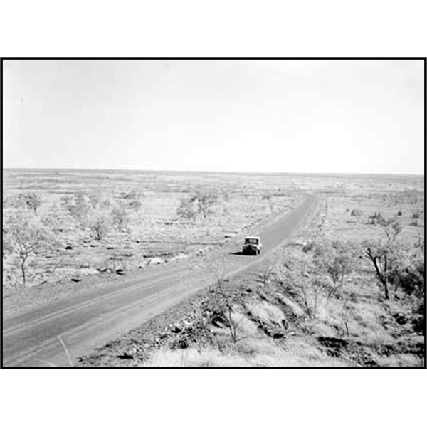
The Stuart Highway near Renner Springs, NT, 1958
A request was made by the Commonwealth Government for the assistance of the state road authorities to rapidly construct a road from
Tennant Creek to Birdum. An inspection was carried out and a proposal put forward which would have the Queensland Department of Main Roads (Qld DMR), South Australian Highways and Local Government Department (SA HD) and New South Wales Department of Main Roads (NSW DMR) carry out the upgrading.
Equipment and men were mobilised and the road from
Tennant Creek to
Larrimah a distance of 322
miles was upgraded to formed gravel road over the period September to December 1940.
The Army recognised that wet season access by road to the Birdum railhead would be difficult so a new location on the railway for the transhipment of material from truck to train was selected 5
miles further north. The name
Larrimah was adopted and most of the
infrastructure, including the hotel, was relocated from Birdum to
Larrimah.
The construction of the Overland Telegraph required access and the on going resupply of the telegraph repeater stations created a track along the route of the telegraph. The alignment was kept cleared of regrowth and minor “improvements” were made over time to
creek and
river crossing approaches.
Charles Todd as the South Australian Superintendent of Posts and Telegraphs and person responsible for the construction of the telegraph therefore represented the first of the construction and maintenance authorities. Initially The Track, during the Overland Telegraph construction, had minimal standards for construction and materials. Hand
tools to clear vegetation, remove trees, stumps and anthills were the initial construction equipment. Fire ploughs, a Vee shaped screed, dragged initially by teams of camels, bullocks or horses and finally by truck or tractor were used from 1900 onwards.
Improvements to the track beside the telegraph were carried out by the South Australian government to enable prospectors and miners to gain access to the gold fields south of Port
Darwin. John George Knight utilising Chinese under the direction of Foreman McNamee made improvements to the road and constructed six bridges.
Once motor vehicles commenced following the track further improvements were made to the approaches to
creek and river crossings. Roads were still constructed by removing trees stumps and anthills by manual labour with fire ploughs towed by horse, camel or bullock teams being used to provide a better surface. On boggy and sandy sections cleared timber was layed in corduroy fashion to enable traffic to traverse the area without bogging. Spinnifex was used in the south to enable sandy country and
creek beds to It was reported by the Administrator in 1924 that “the roads and the
water supply on the stock
routes of the Territory … have never been as good as they are at present” “Roads in the Territory were considered good if an average speed of 25km/hr could be achieved and satisfactory if 15km/hr were possible.”
In 1928 the Commission set up to administer Northern Australia reported that the 5500km of roads under its responsibility “cannot be regarded generally speaking as of a higher standard than bush tracks”. Roads were not constructed to be used during the wet season. The Commission had the opinion that “any attempt to make sections of the most important roads suitable for wet season transportation would be unwarranted at present.”
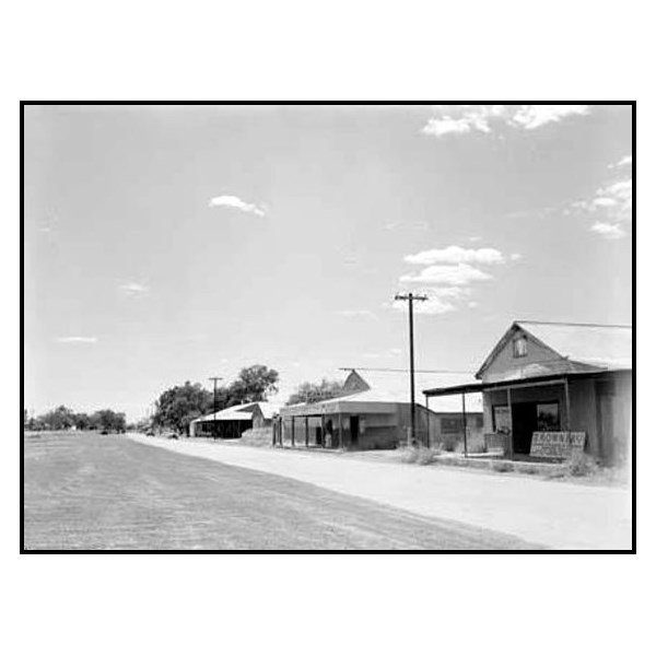
The Stuart Highway through Katherine 1951
Once the road north of Tennant was improved, more development was planned.
The construction of a dam on the Manton River south of
Darwin to provide
water suitable for use in naval vessels lead to the development of a road from
Darwin to Manton River. D D Smith the D of I Engineer had identified a new road alignment from Manton River to
Adelaide River.
Responsibility for The Track was taken over by the Department of Defence Army in 1940 and not handed back to civil control until 1945. Major construction and upgrading works were carried out during this period using the resources of the Army, Department of the Interior, Allied Works Council, SA HD, NSW DMR, Qld MRC, CRB and a USA Army Engineer Battalion. The Civil Construction Corps and the Civil Alien Corps provided lab
The Commonwealth authorities approached the NSW, SA and Qld governments for assistance in constructing a gravel road from
Tennant Creek to Birdum on 25 July 1940. The SA Engineer for Highways and the Chief Engineer DMR NSW along with D. D. Smith D of I Major Dixon Army and Lt Hislop of the
Darwin Overland Supply Unit inspected the proposed road in 1940. The Qld MRC could not get an engineer to attend in the limited time available. A Report was prepared by the two State engineers detailing the climate, existing conditions of roads, railways and other logistics.
The 1940 upgrading of the track from
Tennant Creek to
Larrimah for defence purposes consisted of
clearing, formation and drainage works. The State Road Authorities mobilised large amounts of plant and equipment to carry out the initial upgrading of the highway from flat bladed track to formed gravel road. Equipment included tractors, bulldozers, end loaders, tip trucks, drawn scoops (scrapers) and
water carts.
All authorities brought end loaders to assist with loading gravel, hand loading was considered by one authority but was not used, as it would be too slow! The end loaders were slow and mechanically unreliable so chinamen structures, constructed from locally available materials, were utilised by all authorities to load gravel into trucks using scoops and bulldozers.
The SA HD was involved in the 1940 ninety-day upgrading of 127
miles of the road from
Tennant Creek to Ferguson’s Springs. It was recorded in the Report by the SA Engineer for Highways and the Chief Engineer DMR NSW that “This length is greater than the other two sections, but there are less difficulties to overcome as the location and
clearing is practically complete and a proportion of the construction partially complete.”
The Qld MRC was involved in the 1940 ninety-day upgrading of 90
miles from Ferguson’s Springs to Milners
Lagoon. Queensland mobilised 76 items of plant and 180+ personnel. The work was completed on 6 December. The Queensland organisation maintained their section until 31 December 1941.
The NSW DMR was involved in the 1940 ninety-day 86-mile construction from Milners
Lagoon to
Larrimah. The RAAF provided a plane for the surveyors to fly over the country to get an appreciation of the country they were to traverse. Ground surveys then commenced with some areas of the country being cross-sectioned using the telegraph line as a base. The NSW DMR maintained their works until 31 December 1941.
The NSW DMR in March 1941 at the request of the Army undertook a survey to determine the most suitable location for a road from
Darwin to
Larrimah. The existing track from
Darwin via Manton River to
Adelaide River was identified as being a satisfactory alignment. The DMR then mobilised resources and commenced work on this 68-mile section with completion required prior to the 1942 wet season. Bridge construction crews were also mobilised to construct steel girder bridges with concrete decks over the major streams on the road. As this construction work was taking place the location of the road from
Adelaide River to
Pine Creek and then to
Larrimah was being identified.
The
Adelaide River to
Pine Creek section contained the most difficult terrain. Aerial photographs were taken by Adastra Airways a DMR specialist contractor and then interpreted in DMR head office using the “Azimuth Line Method” developed by the NSW DMR. Plans showing the preferred lines were then sent back to the Territory and pegged by surveyors. This enabled the final alignment to be decided and pegged for construction. The road alignment was finalised by September 1941 and the department was advised by the Military Authorities that they should construct the
Adelaide River
Katherine section of 145miles and that SA HD would construct the balance of 115miles to
Larrimah. NSW DMR would however construct all bridges required on the alignment from
Adelaide River to
Larrimah. Thirteen bridges and the timber decking of five high-level railway bridges were included in the works. The 30mile section from
Katherine to Maranboy turn-off was reallocated from the SA HD to the Australian Army.
The U S Army 808 Engineer (Aviation) Battalion were despatched from the USA to build facilities for US fighter and bomber groups in the Top End of the Northern Territory. They arrived in
Melbourne on 1 February 1942, were then transported by rail to
Alice Springs arriving on 15 February.
Alice Springs to
Larrimah was by the Australian Army convoy system arriving on 18 February. The Battalion was passing through
Katherine when the first air raid on
Darwin occurred. They were off loaded and did minor local works around
Katherine. By 14 April their HQ staff and two Companies were located in
Pine Creek where they undertook “minimum grading and drainage and gravel surfacing over bad spots” over 36
miles of the North South road between the 142mile and 178 ½ mile. The unit completed their roadwork on 11 May and commenced airfield work on
Pine Creek and Mc Donald airstrips.
The Americans had 3 D8 bulldozers that proved a challenge to transport, the Australian road authorities had D7 size machines and low loaders to transport them. The first D8 was trucked to
Larrimah, damaging the trailer, and then walked to
Pine Creek; the remaining two were walked 800
miles on a rotating shift basis from
Alice Springs to
Pine Creek.
The road pavements were initially constructed with gravel, sections adjacent to airstrips and camps were then bitumen sealed by NSW DMR with hot-sprayed bitumen and crushed aggregate wearing surface. The DMR completed the seal of the gravel pavements between
Darwin and
Adelaide River and
Mataranka to
Larrimah in 1943 and
Adelaide River to the 114mile in 1944.
The Department of Defence decided in late 1941 due to increased traffic, to strengthen the Alice Spring to
Larrimah road and provide a bituminous wearing surface. The CRB recommended that three Barber-Greene No.848 heavy-duty mixers be imported from the USA to enable the work to be carried out. Any bitumen used on the project had to be imported into Australia, transported by train to
Alice Springs and then trucked in 3½-ton trucks over a rough high maintenance gravel track to where it would finally be applied to the road.
Construction of Stuart Highway at Charles Creek, north of Alice Springs - culvert being built
The CRB was allocated the task, however the traffic on the road further increased with the completion of the east west road from the rail head at Mt Isa to north of
Tennant Creek. It became necessary to gravel re-sheet the road from
the junction of the North South with the Mt Isa road to
Larrimah a distance of 234
miles. The CRB re-sheeted 95
miles, SA HD 29
miles, RAE 77
miles, and D of I 33
miles.
The sealing work started in June 1942 north of
Tennant Creek with two ½ cubic yard hand fed concrete mixers in one gang and a 21 cubic foot mixer in a second gang, however, two Barber Greene machines soon arrived to replace the hand fed mixers. The 234
miles was completed by February 1943.
The road from
Alice Springs to the Mt Isa turn off was gravel re-sheeted commencing in 1943 with the CRB constructing 141
miles and D of I 190
miles. The CRB then bitumen surfaced the road to
Alice Springs, which with diversions to work on numerous runways, taxiways, and warm up, and dispersal areas on bomber and fighter airstrips, was completed on 13 December 1943.
In addition to design and construction the NSW DMR was responsible for maintenance of the road from the 4-mile
Darwin, to the 332-mile
Larrimah. To manage this workload in1943 the Northern Territory Division of the Department of Main Roads was established with Head Office at Hayes
Creek, the 117mile, and “branch offices” at each of the sites being worked on at the time.
The CRB set up major workshops and administrative
infrastructure in
Tennant Creek to support its operations on the North South Road.
The Northern Territory passed from Military control back to Civil control in 1945. The 32 years from 1946 to 1978 saw the Northern Territory administered by the Department of the Interior with responsibility for construction and maintenance of the Stuart Highway again with the Department of Construction/Works. Initially only maintenance of the pavement was undertaken however in the 1960’s minor upgrading commenced. Major upgrading of alignments and drainage structures to the National Highway Standard, funded by the Federal government occurred from 1970 using Contractors and Day Labour crews.
Limited self-government was granted to the Northern Territory Legislative Assembly in July 1978. Since then the highway has been the responsibility of the Department of Transport & Works and more recently the Department of Planning and
Infrastructure. In this period, with funding by the Commonwealth Government as part of the National Highway Program, the upgrading of the wartime highway to national highway standard was completed in 1992. Bridges constructed in the 1970’s have been upgraded to handle new design axle loadings. Overtaking lanes have been constructed on the
Darwin Katherine section of the road.
.