Next EOTopo Release
Submitted: Tuesday, Dec 06, 2016 at 18:48
ThreadID:
133899
Views:
4362
Replies:
4
FollowUps:
2
This Thread has been Archived
ExplorOz - David & Michelle
Folks,
Just a very early word on the 2017 release of
EOTopo. It is a major piece of work and will put the
EOTopo mapset at the very top of all Topo map products in the country. We are currently very busy with a massive road network conflation task. This task is bridging our Streets & Paths road network with our
EOTopo road network. See this pic from one of our development workstations showing some roads to the west of
Sydney.
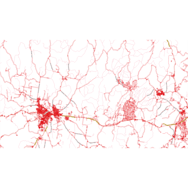
EOTopo 2017 Conflation
The wide red roads represent the streets & paths data with the thinner lines showing the merged
EOTopo road network.
The 2017 mapset will be available in USB, SD & Download for the raster versions and also a whole new online raster and vector tile sets for the
ExplorOz Traveller product, commercial access and other online & download uses.
Release date -
well sorry cannot give that away just yet we have to get past the conflation, merge, update trek and user supplied route files then test and start the build process. But rest assured this will be the biggest update ever under taken in the Topo mapset in terms of the road network and will bring full street level zooms, routing and seemless integration to the
EOTopo product set.
We will keep you up to date as we edge closer to bringing you the best map product on the market, but at this stage we wanted to let you know that the next release is coming and is going to be fantastic.
David
Reply By: Member - wicket - Tuesday, Dec 06, 2016 at 20:38
Tuesday, Dec 06, 2016 at 20:38
Sounds like the downloads will be somewhat large !??
Hope all goes
well
AnswerID:
606455
Reply By: Member - Stephen L (Clare SA) - Tuesday, Dec 06, 2016 at 22:55
Tuesday, Dec 06, 2016 at 22:55
Hi David.
It sound like you have a real big job in hand, and I wish you all the best on this big task.
Do not rush the job, it's better to take it slower and get all roads and tracks as accurate as possible, rather than rushing and having roads out of place.
As I have said to you before, overlay the new Hema 150k over your existing set to see where you need to correct roads and tracks. Have you also thought about putting a call out for high level track files to see actual positions of tracks and roads in real terms, compared to many out of position tracks? The
Birdsville Track is one very good example of this, as if you overlay my track file, you can see how far out it is in real terms.
All the best and I know you will have many sleepless nights of this very big task.
Cheers and Seasons Greetings.
Stephen
AnswerID:
606456
Reply By: Member - Boobook - Wednesday, Dec 07, 2016 at 09:33
Wednesday, Dec 07, 2016 at 09:33
David, will the Memory Map version get the upgrade this time?
AnswerID:
606461
Follow Up By: ExplorOz - David & Michelle - Wednesday, Dec 07, 2016 at 11:14
Wednesday, Dec 07, 2016 at 11:14
I do have plans to send the update to Memory Map when we have it complete.
David
FollowupID:
876201
Reply By: Member - Rod N (QLD) - Wednesday, Dec 07, 2016 at 12:43
Wednesday, Dec 07, 2016 at 12:43
G'day David. I realise I may be pushing you but after you release the 2017 version when is the next revision due? The reason I ask is that the
Toowoomba Second Range Crossing is under construction and due to be finished Dec 2018. This is a significant project which will bypass
Toowoomba on the trip from the south and west to
Brisbane.
This link gives info on the project including links to maps
Toowoomba-Second-Range-Crossing info
I feel that such a significant road should be included in
EOTopo as soon as possible after it is operational.
AnswerID:
606466
Follow Up By: ExplorOz - David & Michelle - Wednesday, Dec 07, 2016 at 17:24
Wednesday, Dec 07, 2016 at 17:24
Rod,
Annually is always the plan provided there is enough requirement. This is a major update and will bring us to a point where we can hopefully easily and quickly adopt updates and change to the dataset.
David
FollowupID:
876211