Are Hard Copy Maps Still in Fashion?
Submitted: Thursday, Jan 23, 2020 at 18:19
ThreadID:
139578
Views:
10209
Replies:
9
FollowUps:
11
This Thread has been Archived
Michael M34
Ok I'm old school and brought up on Topo's and Prismatics, however the 4WD still drips with electronic navigational devices.
I still find I can get my old head around a paper stretched out over the bonnet (when cool :)
Can anyone advise if I can get my paws on a detailed hard copy map showing the tracks up the Darling from
Wentworth to
Bourke showing the Stations. I noticed the on -site map shows definition but not property names.
Cheers
Reply By: Member - shane r1 - Thursday, Jan 23, 2020 at 18:52
Thursday, Jan 23, 2020 at 18:52
G’day Michael,
Hard copies are probably harder to find these days.but can be found.
I think I’m with you on looking at some paper. In recent times I’ve made myself do things like we used to (as much as I can) I look /study the map , then drive by memory, (have to pull up and recheck)wether in the built up areas or out I find it more enjoyable and take more of my surrounds in. Tends to be brain numbing to follow the electronic navigation.
Good luck finding some maps.
Cheers
Shane
AnswerID:
629648
Reply By: Member - Core420 - Thursday, Jan 23, 2020 at 19:00
Thursday, Jan 23, 2020 at 19:00
I use the HEMA Australian Road and 4WD atlas as a backup. I have the 11th edition and it shows station names in the area you are interested in. I found the atlas in a book
shop. But you can probably order it online.
AnswerID:
629649
Follow Up By: Member - McLaren3030 - Friday, Jan 24, 2020 at 08:11
Friday, Jan 24, 2020 at 08:11
I also use the Hema Australian Road & 4WD Atlas, but you can also purchase individual maps of certain areas from Hema on line. Go to their website and check what maps are available for the various areas you are looking at.
Macca.
FollowupID:
904696
Reply By: Member - David M (SA) - Thursday, Jan 23, 2020 at 23:19
Thursday, Jan 23, 2020 at 23:19
Sad to say Michael but I think the art of getting lost has been lost.
Dave.
AnswerID:
629651
Follow Up By: Michael M34 - Friday, Jan 24, 2020 at 09:12
Friday, Jan 24, 2020 at 09:12
Love your sense of humour Dave
Cheers
FollowupID:
904700
Reply By: GarryR - Friday, Jan 24, 2020 at 05:04
Friday, Jan 24, 2020 at 05:04
Hi MichealM34, you do state where you are from, but in
Melbourne I have always used
Melbourne Map Centre for all my Topo maps, they are located in Holmesglen. They have now closed their
shop but still sell online. I have purchased many maps for the Scout group over the years. Not sure if this is the type of map you are looking for, 1:25000 or smaller
AnswerID:
629655
Follow Up By: Michael M34 - Friday, Jan 24, 2020 at 09:21
Friday, Jan 24, 2020 at 09:21
Thanks Garry; Previously been in contact with several Map shops in
Melbourne and
Sydney but will try your suggestion. Hema claims, via their office, they haven't got a dedicated hard copy of 'The
Darling River Run' and the Map shops feedback to date has been they can supply Topo's at $19 or so bucks each. It would take a few for coverage.
Really, I'm surprise that a hard copy map is so difficult to find, I guess the supply and demand thing kicks in . . . no demand.
Cheers
FollowupID:
904701
Reply By: Michael M34 - Friday, Jan 24, 2020 at 09:37
Friday, Jan 24, 2020 at 09:37
Thanks to all for your help, I guess I'm back to my Garmin Nuvi, iPhone, iPad, Laptop and vehicle GPS - I'm just too old school I guess.
As a matter of interest the Australian Army trains in the use of Topo maps still. They don't fail or discharge I guess.
Secondly the Australian Navy, while not training in Topographical Maps ;) still train their captains and first mates in the use of Sextants.
KISS
Cheers
AnswerID:
629660
Reply By: Member - shane r1 - Friday, Jan 24, 2020 at 09:40
Friday, Jan 24, 2020 at 09:40
Map availability has certainly declined, every roadhouse, servo as I guess they’re called now , had a rack of state maps. Same overseas as
well, when travelling (on a bike so can’t carry much anyway) a paper map gives you an easy to see overview of the region. With electronic maps you seem to forever zooming in and out , trying to get a better picture.
I was just thinking I’ll definitely have to treat them with respect . I used to tear them up to fit in my motorcycle
tank bag easier.
Cheers
Shane
AnswerID:
629661
Follow Up By: Michael M34 - Friday, Jan 24, 2020 at 09:53
Friday, Jan 24, 2020 at 09:53
Over 50 years riding/racing bikes Shane and the hard copy map or Trip Notes in the clear plastic holder on the
tank bag was always the go. Quick to whip out a map if needed.
Then came the "Adventure Bikes" and GPS devices. Had a trackie CBR and R1 in my 60's, yep crazy old man :)
Cheers
FollowupID:
904703
Reply By: luxtourer - Friday, Jan 24, 2020 at 09:41
Friday, Jan 24, 2020 at 09:41
Six maps can sell you the NSW 1:100,000 topo maps for the area ($16.95 ea + postage), but you would be up for quite a number, as the map boundaries are rarely convenient. You can though download for free the PDF map files, to check out whether they are what you would want anyway.
Cheers, John
AnswerID:
629662
Follow Up By: Michael M34 - Friday, Jan 24, 2020 at 10:07
Friday, Jan 24, 2020 at 10:07
Thanks mate, that's what I mentioned earlier, it would appear it takes a truck load of Topo's to cover the Darling Trip. Just a simple detailed road map with stations identified has proven elusive.
Something to whip out, put on the bonnet and have a yarn with a local to find
places not shown on devices (or a map for that matter) I warned you I was 'Old School'
Closest so far is the downloadable/print 'Outback Beds' however it doesn't show all stations, just those in the scheme.
Cheers
FollowupID:
904704
Reply By: ExplorOz Team - Michelle - Friday, Jan 24, 2020 at 12:40
Friday, Jan 24, 2020 at 12:40
If you look at EOTopo maps on the website in the free web engine, you are viewing map data without the
Places overlays however when you view EOTopo maps in our app (
ExplorOz Traveller) it also shows the
Places overlays - as this app is designed for navigation and for trip planning etc.
Stations are just one of many Place types that are shown on the map - they are shown with a symbol and in the app you click on these symbols to see a pop up showing the name of the Place and can then click another link to open a full page of info about that Place.
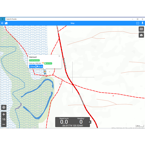
This is
Harcourt Station shown on EOTopo maps when viewed in the
ExplorOz Traveller app.

Screen shot of Map in ExplorOz Traveller
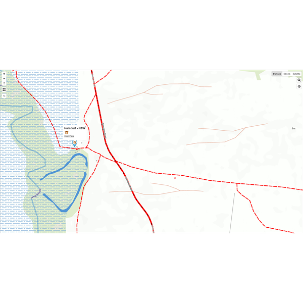
This is
Harcourt Station shown on the EOTopo maps when viewed on the
Places section of the ExplorOz website.

Screen shot taken from website (Places)
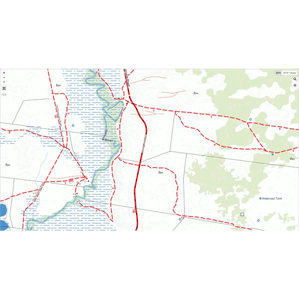
This is
Harcourt Station shown on the EOTopo online webpage on the ExplorOz website

Harcourt shown only by a dot to indicate infrastructure
There is a 4th option to view EOTopo maps and that is the RASTER version which requires other brands of mapping software (eg. OziExplorer, TrackRanger) to view - I don't run that on my desktop so cannot send you a screen shot quickly in the post, but again, it displays differently as these are more like printed maps in that they don't zoom so whatever is produced at export to build the map for that scale is what you see. As there are nearly 90,000 POIs, it is impossible to show the icons for every Place for everywhere in Australia that we have available, so instead for the Raster maps we mostly show text labels for
Places, but include symbols for camps/caravan parks, and major POIs - this is to ensure the map is not too cluttered with symbol overlays. In the app - you can control which symbols by a simple click to hide/show the Place icons - or filter which types to show/hide.
Hope this helps.
AnswerID:
629668
Follow Up By: Michael M34 - Friday, Jan 24, 2020 at 13:18
Friday, Jan 24, 2020 at 13:18
Thanks Michelle, I was a former member and have an older version of 'EOTopo' on the Garmin. It's just my paper map fetish that prompted the post.
My mistake, I thought the version I was looking at was the full monty :)
Regards
Mike
FollowupID:
904709
Follow Up By: ExplorOz Team - Michelle - Friday, Jan 24, 2020 at 13:20
Friday, Jan 24, 2020 at 13:20
Mike may I ask how you got EOTopo on your GARMIN? To my knowledge they aren't compatible??
FollowupID:
904710
Follow Up By: Michael M34 - Friday, Jan 24, 2020 at 13:42
Friday, Jan 24, 2020 at 13:42
Sorry Michelle, to old, too many devices, the download was on the wife iPad I was duly advised.
Cheers
FollowupID:
904711
Follow Up By: ExplorOz Team - Michelle - Friday, Jan 24, 2020 at 13:45
Friday, Jan 24, 2020 at 13:45
Sorry Mike but EOTopo has never been available for iPad either EXCEPT for within the
ExplorOz Traveller app - which is the whole reason we built the app in the first place.
FollowupID:
904712
Follow Up By: Michael M34 - Friday, Jan 24, 2020 at 15:13
Friday, Jan 24, 2020 at 15:13
Try 'Oztopo' installed on Nuvi 2015 - 3rd time proves it?
FollowupID:
904716
Follow Up By: ExplorOz Team - Michelle - Friday, Jan 24, 2020 at 16:16
Friday, Jan 24, 2020 at 16:16
Ah.... there you go, "OzTopo" is a totally different map product and is not one of ours.
It's specifically designed for Garmins, Nuvis etc that need "vector" mapping. It also contains much older mapping and combines various 3rd party data sources together. With EOTopo we do not use any third party data sources - it is all updated to the latest 2019 maps, with live updates for POIs directly from ExplorOz
Places. Completely different.
So, back to your original issue - you wanted to see Names of Stations on the map - yes EOTopo supplies that. Take a look at our app
ExplorOz Traveller and get the latest EOTopo 2019 app version map licence to go with it and you're good to go - just put it all on your phone, tablet, iPad or a laptop (if it has GPS).
FollowupID:
904723
Reply By: Candace S. - Sunday, Jan 26, 2020 at 06:28
Sunday, Jan 26, 2020 at 06:28
I don't know where you're physically located, but The Map
Shop in
Adelaide is packed with paper maps and atlases! Anthony would be happy to talk to you about maps if you give him a ring. :)
AnswerID:
629720