Finding the Border posts SA/VIC/NSW along the Murray
Submitted: Thursday, Apr 21, 2022 at 19:03
ThreadID:
143592
Views:
8171
Replies:
4
FollowUps:
12
This Thread has been Archived
Member - Raymond J
Hi Everyone,
Travelling along the Murray in June and was wondering if by any chance that the State border post of SA/VIC/NSW are able to be visited and photographed, I realise the border runs in the middle of the Murray. Just wondering if they ever erected some border posts on the edge of the river, and if they did, are they accessible to the public. I’d like to thank everyone at this time for any help and information thank you all.
Regards Ray J.
Reply By: ian - Thursday, Apr 21, 2022 at 19:45
Thursday, Apr 21, 2022 at 19:45
Hi Ray,
A couple of things I would like to let you know about the border point you plan to visit, that hope are useful.
1/ Basically, the entire
Murray River until S.A. is in NSW, with the state border being on the Victorian bank.
2/ I am not aware of any 3-state border point because the North-South
boundary of SA and NSW does not align with the VIC -
SA border. They are kilometres apart, apparently because when the VIC -SA fence was put in, the party moved too far west, maybe at the request of Victorian graziers.
This is still a hot issue in some parts.
ian
AnswerID:
640280
Follow Up By: Member - Raymond J - Thursday, Apr 21, 2022 at 20:56
Thursday, Apr 21, 2022 at 20:56
Hi Ian,
Thanks for the info on the States borders and as you pointed out in the second info paragraph they don’t align at all, thanks for that. Was hoping to at least find one or both of the broader posts if any were put in place. Have got some GPS coordinates of MacCabes Corner from another post and will try and borrow a GPS off some friends for the trip. The brother and I will try and visit a couple of other corners of the states and also the centre of Australia on this trip as
well after trying to photograph the Princess Parrot at Neales
Junction.
Regards Ray
FollowupID:
919355
Follow Up By: Member - nickb boab - Friday, Apr 22, 2022 at 02:16
Friday, Apr 22, 2022 at 02:16
When you travel along the river there is a large
sign on NSW side of river re border , can't remember what it said ? . Up stream of customs house .
FollowupID:
919357
Follow Up By: Nomadic Navara - Saturday, Apr 23, 2022 at 00:31
Saturday, Apr 23, 2022 at 00:31
Quote "2/ I am not aware of any 3-state border point because the North-South
boundary of SA and NSW does not align with the VIC -
SA border. They are kilometres apart, apparently because when the VIC -SA fence was put in, the party moved too far west, maybe at the request of Victorian graziers."
It was purely a surveying error. The party that surveyed the Vic border established a starting point on the southern coast line. They then started their transit from there.
The NSW/SA survey was done much later. By that time there was a telegraph line between
Sydney and
Adelaide, they used the electrical signals from each end to establish a control station with the timing signals from the telegraph.
Charles Todd's timing point
FollowupID:
919385
Follow Up By: Stephen L (Clare) SA - Saturday, Apr 23, 2022 at 08:29
Saturday, Apr 23, 2022 at 08:29
Hi Peter
Is that a new marker? As I have not seen that one and looks like it must have been put there in the last couple of years?
The
Todd Obelisk was the official state
border marker for NSW and SA
FollowupID:
919386
Follow Up By: Nomadic Navara - Saturday, Apr 23, 2022 at 10:02
Saturday, Apr 23, 2022 at 10:02
Stephen, that marker is not on the border. It is 2
miles, 44 chains, 69 links west of the border. It is
the spot where Todd established an accurate reference to find the actual longitude for the border. The round peg there has a date of 20th April 1991 on it so the whole structure may date from that date.
We saw the border obelisk before driving on to the above spot. There is supposed to be a newer marker beside the
Wentworth road just down the
hill from the obelisk but I did not locate it.
FollowupID:
919390
Reply By: Rod N - Thursday, Apr 21, 2022 at 20:07
Thursday, Apr 21, 2022 at 20:07
Have a look at the blog by Stephen L titled '
MacCabe Corner'. Also click on the under lined link for a
Places entry.
AnswerID:
640281
Follow Up By: Member - Boobook - Friday, Apr 22, 2022 at 08:23
Friday, Apr 22, 2022 at 08:23
The Vic
SA border on the river is
Here Google is spot on. There is a
sign on the river edge but you need a smal boat to get to it as it is very swampy in that area most of the time.
There is a great book on the border dispute and interesting reading about where the border really is. There ae about 5 possibilities in the stretch of Murray. The concensus is that it is half NSW half SA but SA fisheries patrol the whole width as if it is SA.
FollowupID:
919360
Reply By: Member - McLaren3030 - Friday, Apr 22, 2022 at 08:31
Friday, Apr 22, 2022 at 08:31
Hi Raymond J,
You mentioned in a reply to your post that you wanted to visit a couple of other State Border corners. If by chance you get to
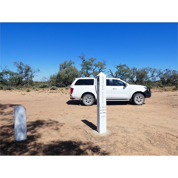
Surveyor Generals Corner, W.A./N.T./S.A. Corner, there are actually two corner posts. Similar to NSW./Vic./S.A. corner, it is not aligned. The second post is about 200 m further down the track around a bend, and not visible from the first post. When we were there a few years ago, the second post did not have a
plaque on top, someone had “souvenired” it.
This corner is in an area controlled by the Traditional Custodians, so you will need a couple of permits in order to access it. If you go on line and “Google”
Surveyor Generals Corner, you should be able to see all the info you need in order to access the area. One of the elders (Eddy) is buried nearby, so be respectful when you visit the area.
Surveyor Generals Corner
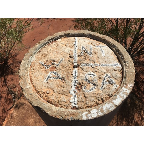
Surveyor Generals Corner
Macca.
AnswerID:
640288
Follow Up By: Member - Raymond J - Friday, Apr 22, 2022 at 15:30
Friday, Apr 22, 2022 at 15:30
Hi Macca,
I have found out a little about the Surveyor General Corner and I learnt that when visiting the corner that the other post was around the bend in the road a little way. Started a couple of years ago to under take this trip with the brother but Covid put a stop to
mine and everyone else’s trips. But thanks for
the tip. Been trying to gain permits for a couple of months and also now while we are communicating at this time. I have read several post you put up and read several you answered to help others with your knowledge and experience of the outback, I’d like to thank you for that Macca and hope to meet you in person in the near future.
Regards Ray.
FollowupID:
919371
Reply By: Stephen L (Clare) SA - Friday, Apr 22, 2022 at 09:38
Friday, Apr 22, 2022 at 09:38
Good Morning Raymond
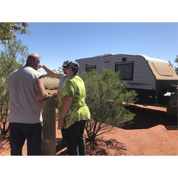
Not sure if any of the replies have actually visited the actual Border Posts that you require to see and visit, but here is what you need to know from our own personal experience.
Firstly you can not visit any of the posts from the land , all require that you visit them via the actual
Murray River and both from 2 different launching locations, many kilometres apart.
First is the
MacCabe Corner and the NSW/
SA Border posts.
To access these 2 seperate posts, you need to launch at
Higgins Cutting and then head upstream for around 4 odd kilometres.
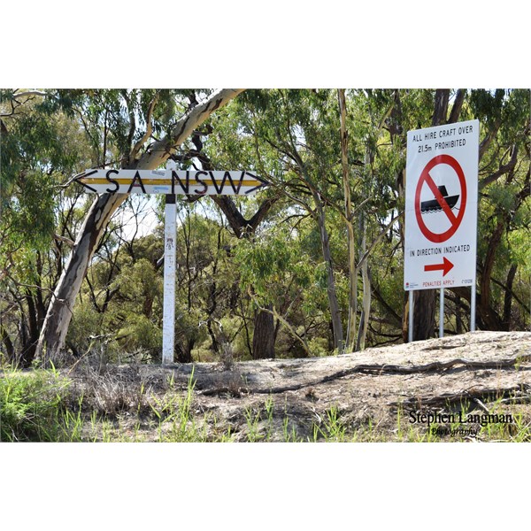
The easy one to spot first is the large NSW/
SA Border Post, high up on the bank in a cleared area.
MacCabe Corner is a little harder to find, around 200-300 metres from the NSW/SA marker, but downstream and camouflaged by River Coober and River Red Gums. When you climb to the top of the bank, its is in a small cleared area.
As for the SA/Vic
Border Marker, this is again accessible only from the Murray, but downstream from the Customs House. As you are heading downstream, it is 3 odd kilometres in a small
clearing.
Happy Hunting.
Higgins Cutting Launching spot
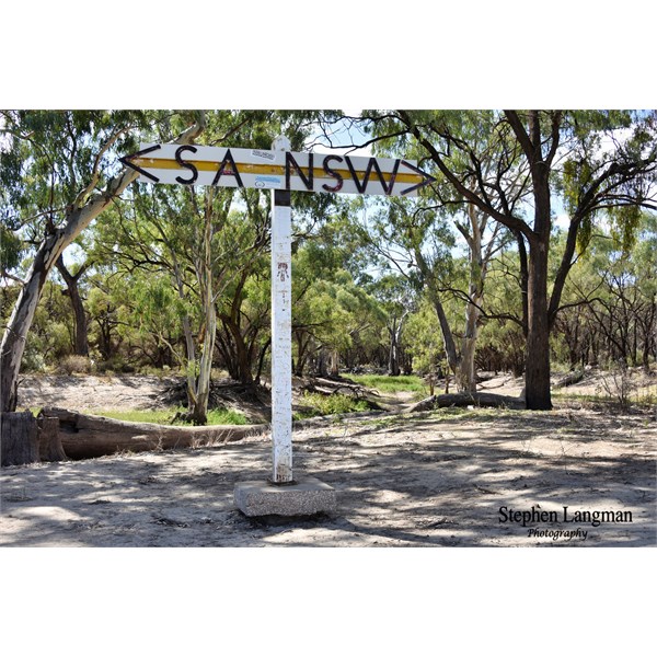
The easy to located SA/NSW Marker upstream from Higgins Cutting
The easy to located SA/NSW Marker upstream from Higgins Cutting
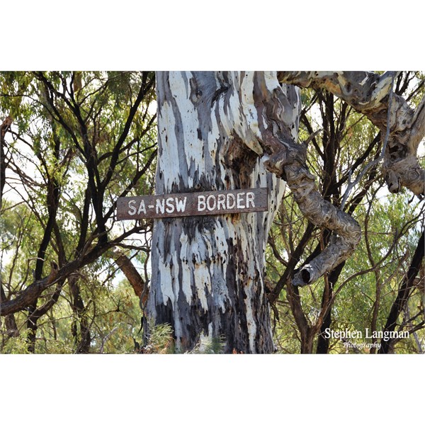
Unofficial Sign on large River Red Gum at the SA/NSW Border Marker
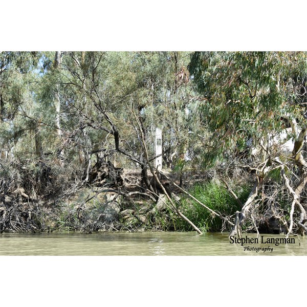
The harder to find MacCabe Corner Marker, camouflaged by River Coober and River Red Gums

Small cleared area at MacCabe Corner
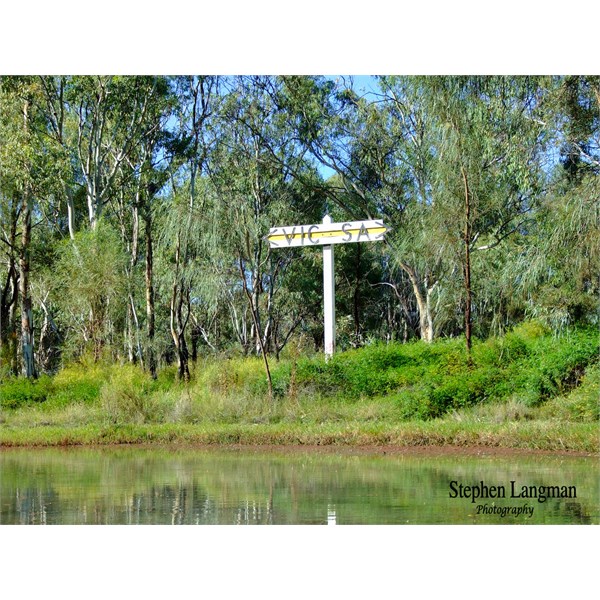
Access to the Vic/SA Border marker is from the Customs House launching area and downstream.
AnswerID:
640290
Follow Up By: TrevorDavid - Friday, Apr 22, 2022 at 10:30
Friday, Apr 22, 2022 at 10:30
Morning Raymond, Stephen & others
Actually walked into
MacCabe corner about a month ago, roughly around 3k each way. There is a properly constructed walkers entry on the fence between the Murray Sunset national
park and the private property . You can drive right up to this entry in the
park. You follow a little used vehicle track, easily followed on
ExplorOz Traveller.
Regards
TrevorDavid
FollowupID:
919364
Follow Up By: Stephen L (Clare) SA - Friday, Apr 22, 2022 at 10:41
Friday, Apr 22, 2022 at 10:41
Hi Trevor
When we did it, the only access was the river, so good to see they now have a track there, but you still will not be able to visit the SA/NSW Borders marker across the other side of the Murray if you walk in.
FollowupID:
919365
Follow Up By: Member - Raymond J - Friday, Apr 22, 2022 at 15:47
Friday, Apr 22, 2022 at 15:47
Hi Stephen,
Thanks for the info mate but by the off chance it may be possible to walk in to view one of the posts as TrevorDavid has pointed out. It’ll be a pity we won’t be able to view the other one as we won’t be carrying a boat and the
water will be too cold for us Nth Queenslanders to venture into for a swim. Thanks again.
Regards Ray.
FollowupID:
919372
Follow Up By: TrevorDavid - Friday, Apr 22, 2022 at 18:39
Friday, Apr 22, 2022 at 18:39
So very true Stephen, go’s without saying.
Regards
TrevorDavid
FollowupID:
919380