Yulara to Dalhousie via Amata Tjurma
Submitted: Tuesday, Mar 05, 2024 at 17:30
ThreadID:
147154
Views:
3754
Replies:
4
FollowUps:
13
This Thread has been Archived
Anthony B13
Hi all, my partner and I are doing a Finke River/Red Centre/Simpson Crossing trek this coming July/August and I am hoping someone can advise if the track between Petermann Road and Amata Tjurma is open to travellers please? On the Hema GDT Central sheet this is marked as Ernest Giles Road with "permit required", however Mr Google has this marked as "Alpara". This joins the Gunbarrel Hwy at Amata Tjurma where we can then get back to the Stuart briefly before turning on the Finke Rd to head to Dalhousie. Would really appreciate if someone could let us know if we can use this track and if so, where we would acquire any permits on we would be very appreciative. Thank you in advance, Anthony and Tracey.
Reply By: Member - McLaren3030 - Wednesday, Mar 06, 2024 at 07:14
Wednesday, Mar 06, 2024 at 07:14
Hi Anthony,
The Ernest Giles Road does not join the
Gunbarrel Highway, it runs between the Luritja Road and the Stuart Highway, and does not require a permit. I have driven this road on several occasions, it can have some corrugations, and has a couple of sandy patches as
well.
The road that you are referring to that joins the
Gunbarrel Highway is called the Mulga
Park Road, and is much further south. It runs between the Stuart highway just north of the N.T./S.A. border and joins the Lasseter Highway just east of
Curtin Springs. I have also driven this road on several occasions. A permit is required for this road if you continue west past Mulga
Park towards Armata into the APY Lands. You will most likely not get a Permit to cross the APY Lands.
Are you looking to travel from near
Hermannsburg south to the Stuart Highway? If so, this road is called either the
Palm Valley Road, or the
Finke River Road and follows the
Finke River. It does eventually join the Ernest Giles Road that ends up at the Stuart Highway. I believe this is the road you are actually referring to. I drove this road back in 2004, it is very Sandy in patches as it follows in and out of the
Finke River.
Macca.
AnswerID:
645432
Reply By: Anthony B13 - Wednesday, Mar 06, 2024 at 11:33
Wednesday, Mar 06, 2024 at 11:33
Hi Macca,
Thanks so much for the response. You are correct, we will be travelling along the
Finke River (
Palm Valley Rd) south where we meet the (what i suspect) is the more commonly known
Ernest Giles Rd. From there we will pick up the Luritja Rd and head south picking up the Lassiter Hwy to
Yulara.
The section i am speaking of is heading 17km east from Mutitjulu along Petermann rd until you hit a track that heads south which on Google maps says its Alpara, but on the Hema GDT Central sheet actually has it marked as
Ernest Giles Rd (confusing i know and i assume it used to connect with the
Ernest Giles Rd in the North before changes were made to the areas out there). That runs almost directly south to Amata, picks up the (not old) Gunbarrell Hwy which appears to eventually meet
Mulga Park Rd where they continue east to the Stuart.
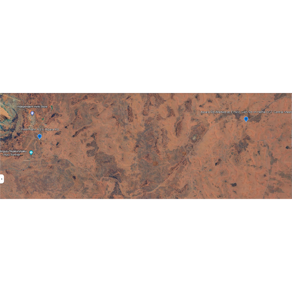
Image 1
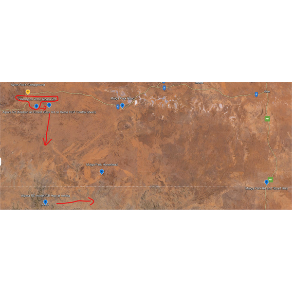
Image 2
I have attached a couple of images, Image 1 shows from Mutitjulu to Alpara Rd, the 2nd image shows a wider picture with the reference points mentioned. As i mentioned in my post, Hema has this track as requiring a permit. Hope all this makes sense.
AnswerID:
645434
Follow Up By: Anthony B13 - Wednesday, Mar 06, 2024 at 11:55
Wednesday, Mar 06, 2024 at 11:55
As a follow up, this is a screenshot from ExplorOz which have the track marked as the Amata-Mutjitjulu Track.
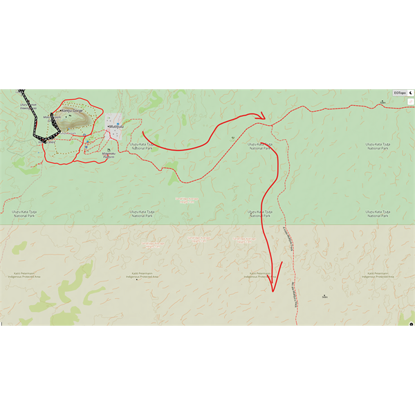
Image 3
FollowupID:
925729
Follow Up By: Member - McLaren3030 - Wednesday, Mar 06, 2024 at 16:21
Wednesday, Mar 06, 2024 at 16:21
Hi Anthony,
I am not sure if the roads you want to take from the Lasseter Highway are open to the public. You may have to ask the Central Lands Council which I think have authority of these roads.
As an alternative, once you have finished at Yulara/Uluru/
Kata Tjuta, head east on the Lasseter highway past
Curtin Springs, and head down the Mulga
Park Road to the Stuart Highway. Then head North on the Stuart Highway to
Kulgera, then head east on the Finke Road to Finke.
Macca.
FollowupID:
925731
Follow Up By: Anthony B13 - Thursday, Mar 07, 2024 at 08:56
Thursday, Mar 07, 2024 at 08:56
Thanks Macca, I had the same (quite logical really) idea and sent an email to CLC yesterday, will see what they come back with. If we can't get through this way our plan B was exactly that,
Mulga Park Rd, Stuart, Finke Rd to a
well earned rest at Dalhousie. Thanks for all the advice Macca.
FollowupID:
925732
Reply By: Peter_n_Margaret - Wednesday, Mar 06, 2024 at 12:19
Wednesday, Mar 06, 2024 at 12:19
I think the chances of getting a permit for the route you want or anything south of the SA-NT border are almost nil.
The Mulga
Park road is a nice drive. It is always our route choice.
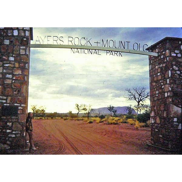
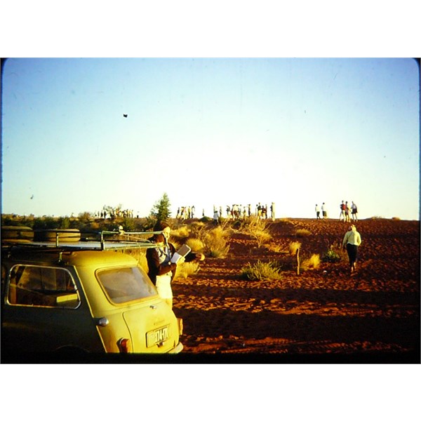
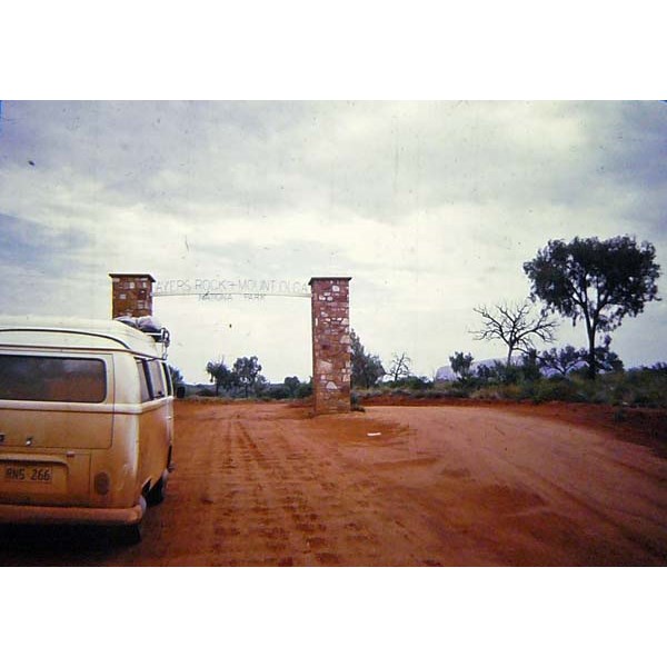
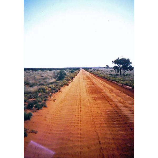
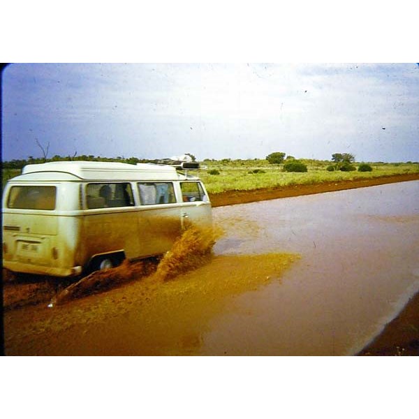
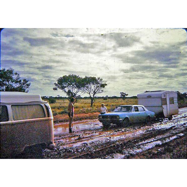
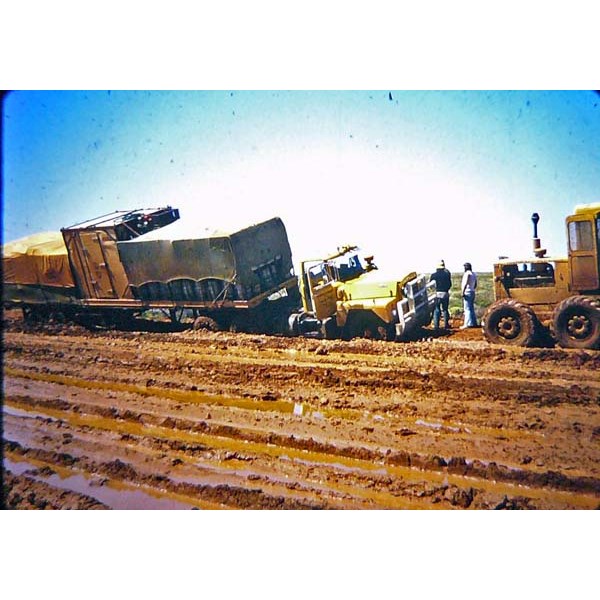
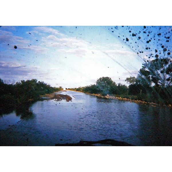
Just for interest, the Peterman Road that goes west from near Curtain Springs to the Mutitjulia community is the original access road to Uluru before the community was established and before Yalara was "developed".
We drove that route on several occasions from 1967 (in Minis) and 1974 (in a VW Kombi camper).
Camping was about 1km east of Uluru.
1967
1967
1974
1974
1974
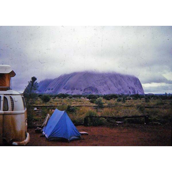
1974
Mulga Park road 1974
ps.... we fitted a set of snow chains to the rear and drove on. :)
Cheers,
Peter
OKA196 motorhome
AnswerID:
645435
Follow Up By: Anthony B13 - Thursday, Mar 07, 2024 at 09:11
Thursday, Mar 07, 2024 at 09:11
Hi Peter, wow we are so jealous...to have had the opportunity to explore those lands at a time when we were a much simpler country would have been incredible. Absolutely love the photo's :-)
Looking at the Hema map yes I suspect you are correct as the Apara-Makiri-Punti API lands extend up to the NT/
SA border. I have found what appears to be a
well used track about 17 kms north of the border that heads east, ultimately meeting up with
Mulga Park Rd at the
Homestead. Image attached, you might know it? If we can somehow secure a permit to get to that point from the CLC, we should be able to use that to get across to the Stuart. Otherwise yes as per your suggestion the
Mulga Park Rd is our plan
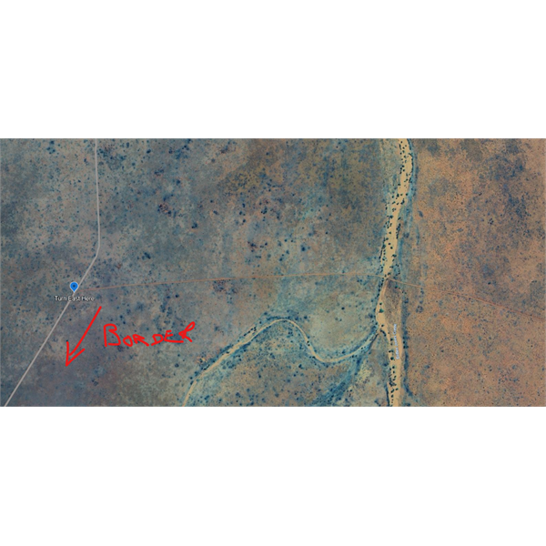
Track heading east before the border.
B.
Thank you so much for your insights and those brilliant photo's!
FollowupID:
925733
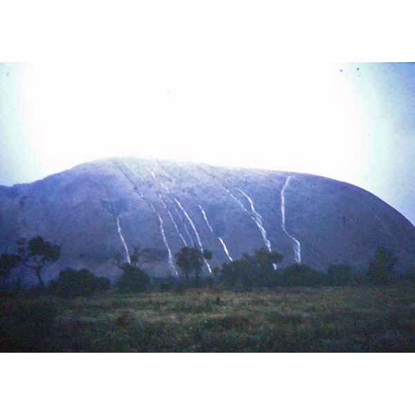
Follow Up By: Stephen L (Clare) SA - Thursday, Mar 07, 2024 at 12:03
Thursday, Mar 07, 2024 at 12:03
Those photos bring back great memories to me Peter.
You and I must have been there at the same time in 1974, all that mud and seeing it raining on
the rock, yet 12 months later it was perfect.
Loved the old original campgrounds at the base of
the rock, it was so special
FollowupID:
925735
Follow Up By: Peter_n_Margaret - Thursday, Mar 07, 2024 at 12:24
Thursday, Mar 07, 2024 at 12:24
It took us 9 days to drive from Alice to
Adelaide via Uluru in the wet.
A couple of years earlier we went to Uluru from
Adelaide and back for an
Easter weekend in a Mini.
Young and stupid.
People do
Adelaide to Alice in daylight in 1 day these days.
Cheers,
Peter
OKA196 motorhome
FollowupID:
925736
Follow Up By: Bob Y. - Qld - Thursday, Mar 07, 2024 at 21:13
Thursday, Mar 07, 2024 at 21:13
Back in August, ‘74, a group of us from
Rockhampton Downs, NE of
Tennant Creek, headed down to the Alice, then onto Ayers Rock.
Overnighted there, climbed
the Rock, then headed off mid afternoon, when the rain started to get a bit fair dinkum.
Just on dark, pulled off the road at a patch of gidgea, and just as we got a fire going, the rain came down again. Not real comfortable for 6 or 7 sweaty bodies in a
sedan & a ute! It mightn’t have rained too much, because we managed to get back on the road at daylight. 2 HT Holdens.
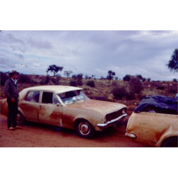
John Schmidt not happy with his dirty sedan. My Ute loaded up & dirty too.
Bob
FollowupID:
925738
Follow Up By: Peter_n_Margaret - Thursday, Mar 07, 2024 at 22:12
Thursday, Mar 07, 2024 at 22:12
74
74
W of Pimba 74
74
We did a lot of walking. Wore out a set of snow chains.
Cheers,
Peter
OKA196 motorhome
FollowupID:
925739
Reply By: Member - Bigfish - Thursday, Mar 07, 2024 at 06:14
Thursday, Mar 07, 2024 at 06:14
I did a lot of work and travel in the APY lands. I doubt very much that you will get a permit in anything to do with APY homelands country.
AnswerID:
645438
Follow Up By: Anthony B13 - Thursday, Mar 07, 2024 at 09:15
Thursday, Mar 07, 2024 at 09:15
Hi Bigfish, thanks for the info, no doubt living and working on those lands you would have good insights. My partner and I are at that stage in life where we want to slow down and actually do something meaningful and we are exploring the possibility of moving and working remote, ideally in a small community somewhere. No grand ideas of saving the world, just having a bit of a peaceful life and making what small change for the positive we can. Of course it will also allow us to explore out there further without having to spend 3 days travelling from
Brisbane to get anywhere!
FollowupID:
925734
Follow Up By: Member - Bigfish - Friday, Mar 08, 2024 at 08:57
Friday, Mar 08, 2024 at 08:57
Working and living in a remote aboriginal community can be very challenging. A thick skin, patience and a no nonsense attitude is required. If your looking for a more relaxed lifestyle in retirement I,d be very careful about selecting which community you choose. Smaller country towns are perfect for retirement to escape the rat race. Cannot believe people borrowing 1/2million + dollars to buy a house and live in a soulless city. You would be surprised just how community minded most small towns are. They are often looking for various workers and houses are a lo cheaper to purchase if the town suits. Good luck with your travels.
FollowupID:
925740
Follow Up By: Anthony B13 - Friday, Mar 08, 2024 at 17:28
Friday, Mar 08, 2024 at 17:28
We aren't quite ready for retirement just yet, if only we could afford that! We both work professionally in the daily grind office jobs, but have between us a mountain of experience living/working in remote areas of the world, my partner lived and worked in the middle east for 22 years, i myself have lived on sheep stations, in small towns, built boats and travelled to some of the...less touristy
places in the world. This for us is about getting away from this city grind we both disdain and acknowledging what drives us. Community, being human and treating others the same, exploring this freaking fantastic country of ours and hopefully give a little something, somewhere, where it would be most beneficial. Thank you Bigfish for your wise and practical words, and happy travels!
FollowupID:
925741
Follow Up By: Peter_n_Margaret - Friday, Mar 08, 2024 at 18:06
Friday, Mar 08, 2024 at 18:06
We retired earlier than most and became pensioners as soon as age allowed.
You can travel this country at lower cost than most would believe.
Add some volunteering in National Parks and cattle stations (and other
places) and costs reduce even more. Add the unique experiences that these
places provide and it is a pretty good life :)
All properties have secrets that they only share with those who they trust.
We also had 2 years volunteering in Fiji. Life changing and financially neutral.
That said, there are plenty of paid jobs out there. We are offered them, but explain that it took 25 years to get rid of the last ones we had. :)
Cheers,
Peter
OKA196 motorhome
FollowupID:
925742
Follow Up By: Anthony B13 - Thursday, Mar 14, 2024 at 12:06
Thursday, Mar 14, 2024 at 12:06
Love this "We are offered them, but explain that it took 25 years to get rid of the last ones we had." That is really good info Peter, thank you and
well done on achieving the lifestyle you aimed for. While probably not in a position to retire early, we will do ok when we do and fully intend on travelling full time. Until then, we are committed to a total lifestyle change that enables us to live how we wish and contribute to country and the communities as best we can. Happy and safe travels!
FollowupID:
925779