GPS Coordinates 'Not a valid location' message on TomTom.
Submitted: Sunday, Apr 13, 2014 at 17:20
ThreadID:
107248
Views:
4222
Replies:
9
FollowUps:
9
This Thread has been Archived
Drummy53
Greetings from
Gilgerabbie Hut camping area on the Nullarbor, SA. We found the
campsite thanks to the written directions in the Boiling Billy
Camping guide to South Australia. However, the GPS coordinates given in the Boiling Billy
Camping guide S:31 32.487 E:130 47.360 is regarded as 'not a valid location' on TomTom. My SPOT phone GPS coordinates for the
campsite are 31.54137S. 130.78922E. Again TomTom says this is not a valid location. I have noted
the SPOT phone map does not display the unnamed access road 11 Kim's west of the
Nullarbor Roadhouse. An explanation of what is happening would be appreciated. Would the HEMA GPS find this
campsite? And yes, before I get wrapped over the knuckles, I will make certain I have paper maps before getting more adventurous!
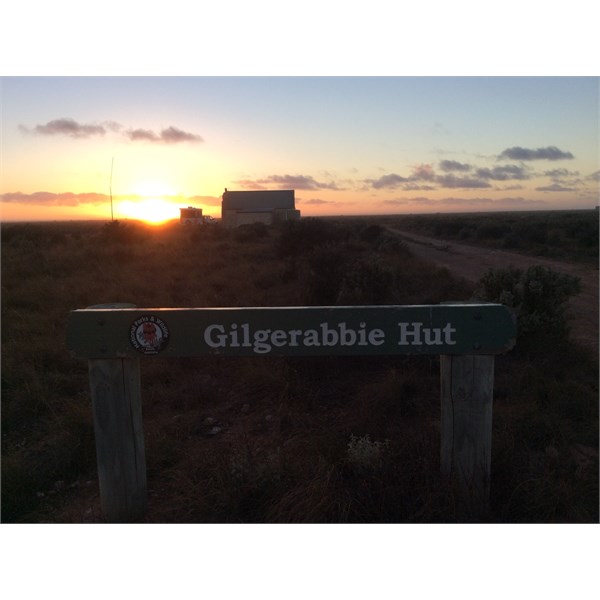
Gilgerabbie Hut, Nullarbor, SA
Reply By: Member - Andrew & Jen - Sunday, Apr 13, 2014 at 17:40
Sunday, Apr 13, 2014 at 17:40
Ian
What came to mind was that you might have the Tom Tom set to degrees, minutes and seconds rather than degrees/decimals.
What does the Tom Tom read for that location?
Worth a first check
Cheers
Andrew
AnswerID:
530483
Follow Up By: Drummy53 - Sunday, Apr 13, 2014 at 20:33
Sunday, Apr 13, 2014 at 20:33
Thank you for your reply.
I set TomTom to degrees/decimals and then tried my location for the following message, 'No usable locations near GPS position'. Same message for d.m.m. and d.m.s. TomTom has worked on d.m.m. using coordinates from Boiling Billy
Murray River and South Australia.
Also receiving a not valid GPS location for
Koonalda Homestead camping area, 93.4 Kim's west of
Nullarbor Roadhouse.
I am getting a valid location for first
rest area west of
Nullarbor Roadhouse.
Regards, Ian
FollowupID:
813414
Reply By: Member - Frank P (NSW) - Sunday, Apr 13, 2014 at 17:44
Sunday, Apr 13, 2014 at 17:44
Ian,
I'm not familiar with Tom Tom but my guess is that the track the location is on is not in Tom Tom's database, therefore it thinks you can't get to the location.
I use CoPilot Live from ALK Technologies (
https://www.alk.com). It available for Android from Google Playstore. Don't know about iOS.
Copilot is not a "4WD" navigator, but it has many, many minor roads, tracks and firetrails that other street navigators don't have, including the track to
Gilgerabbie Hut.
If the Hema navigator has that track in its database I imagine it would get there too.
Cheers
AnswerID:
530484
Follow Up By: Drummy53 - Sunday, Apr 13, 2014 at 21:02
Sunday, Apr 13, 2014 at 21:02
Thank you for your reply.
Beginning to think that campsites accessed south or north of the Eyre Highway are not going to show a valid GPS position on TomTom.
Will have a look at CoPilot.
Regards, Ian
FollowupID:
813419
Reply By: Member - Boobook - Sunday, Apr 13, 2014 at 17:48
Sunday, Apr 13, 2014 at 17:48
The co-ordinates given in Boiling Billy are degrees, decimal minutes. Your SPOT phone is set to decimal degrees. They are the same spot.
It is possible that your Tom Tom is set to degrees minutes seconds or even UTM
This site is useful
converter
AnswerID:
530485
Follow Up By: Drummy53 - Sunday, Apr 13, 2014 at 20:52
Sunday, Apr 13, 2014 at 20:52
Thank you for your reply.
TomTom is set to d.m.m'.
Coordinates have previously worked along the
Murray River and SA. Cannot get a valid GPS position for
Gilgerabbie Hut or
Koonalda Homestead. However, I do get a valid GPS position for first
rest stop west of Nullarbor
Homestead.
I had another look at
the SPOT location map using Satellite mode. The access road and surrounding tracks are now visible.
Regards, Ian
FollowupID:
813416
Reply By: evaredy - Sunday, Apr 13, 2014 at 21:16
Sunday, Apr 13, 2014 at 21:16
I had a top of the line TomTom before my current model 4x4 GPS.
It is useless to say the least, the minute you venture 50 meters of the blacktop it gets lost and doesn't display anything.
It happened numerous times with various
camp sites that were a little way off the blacktop. I was unable to save different
places as favorites, because of this, which got really frustrating.
So I am guessing this is the reason, once off the blacktop is won't register as being anywhere.
Just as a test, next time you use it, stop before you leave the road and test it to see it it knows where you are. Then drive off the road about 50 to 100 meters and try it again. My guess is it will fail to pick up your location.
I bought a GPS unit that runs 4x4 off road as
well as normal street navigation. It is 1000% better than Tomtom.
The street navigation software is IGO Primo with NAVTEQ Australia + NZ. Even though it is supposedly only street navigation, I am very impressed that it knows where you are, even when a long way from the blacktop. It also has a lot more dirt roads and side tracks in the mapping software.
For off road it uses Ozi Explorer and will run Hema Maps, Westprint 4WD maps plus , BackCountry 4WD maps, NATMAP Topo maps.
AnswerID:
530501
Follow Up By: Member - Frank P (NSW) - Sunday, Apr 13, 2014 at 22:02
Sunday, Apr 13, 2014 at 22:02
Ian,
Copilot uses Aus and NZ mapping from NAVTEQ. Don't know if they're the same maps or detail, but you possibly have a choice of devices with the same excellent mapping.
Cheers
FollowupID:
813423
Follow Up By: Drummy53 - Sunday, Apr 13, 2014 at 22:02
Sunday, Apr 13, 2014 at 22:02
Thank you for your reply.
Appears that paper maps and a compass are not obsolete!
The
Gilgerabbie Hut camping area Is 4.7 Kim's west of the Ayre Highway. At night the
Nullarbor Roadhouse lights are clearly visible. So are the Road Trains sailing up and down the Ayre Highway.
Surprised TomTom is not finding a valid GPS position for this
camp site.
The TomTom has previously found
camp sites on the
Murray River I would regard as 'obscure'.
Will review the information you have so graciously supplied regarding IGO Primo.
Regards, Ian
FollowupID:
813424
Follow Up By: Drummy53 - Sunday, Apr 13, 2014 at 22:06
Sunday, Apr 13, 2014 at 22:06
Should read 4.7 Kim's SOUTH OF Ayre Highway.
Ian
FollowupID:
813425
Follow Up By: rocco2010 - Sunday, Apr 13, 2014 at 23:18
Sunday, Apr 13, 2014 at 23:18
Gidday
Read an article the other day suggesting that Edward John Eyre was one great Australian explorer who didn't always get the recognition he deserved...
Cheers
FollowupID:
813431
Reply By: Sand Man (SA) - Monday, Apr 14, 2014 at 07:39
Monday, Apr 14, 2014 at 07:39
Ian,
I entered the coordinates you mentioned into my Tomtom 820 Live and it simply stated Unnamed Road then proceded in calculating the route.
My device is set to Degrees (d.d) in Settings - Units - Coordinate display.
AnswerID:
530508
Reply By: WBS - Monday, Apr 14, 2014 at 08:46
Monday, Apr 14, 2014 at 08:46
TomTom's are useless as soon as you venture off road and many times useless on the road that is anywhere remote. Its the wrong gadget for that type of navigation. I suspect however, that is not the reason why it wouldn't accept the coordinates. I think you may have entered the coordinates in the wrong format. I agree with Sandman that you should set your unit to accept D.ddd then learn how to recognise different format and then how to convert any other format to D.ddd.
WBS
AnswerID:
530512
Follow Up By: Drummy53 - Monday, Apr 14, 2014 at 10:47
Monday, Apr 14, 2014 at 10:47
Thank you for your reply.
Appears I have some homework to do regarding GPS navigation.
Cheers, Ian
FollowupID:
813467
Reply By: Member - Scott M (NSW) - Monday, Apr 14, 2014 at 09:42
Monday, Apr 14, 2014 at 09:42
Your SPOT coordinates on Google Earth are pretty 'spot-on' if you excuse the pun...

google earth
AnswerID:
530514
Follow Up By: Drummy53 - Monday, Apr 14, 2014 at 10:28
Monday, Apr 14, 2014 at 10:28
Thank you Scott M for your reply.
Reassuring to know SPOT is so accurate.
Regards, Ian
FollowupID:
813461
Reply By: get outmore - Monday, Apr 14, 2014 at 10:25
Monday, Apr 14, 2014 at 10:25
to keep it simple I wouldnt be using the tom tom for that purpose - its not what there for
id be using a proper offroad navigation system like Ozi explorer
AnswerID:
530516
Reply By: equinox - Monday, Apr 14, 2014 at 22:49
Monday, Apr 14, 2014 at 22:49
What a great quiet spot on the plain.
I just passed through however would be a nice place to
camp out for a day or so!!
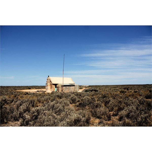
Gilgerabbie Hut
AnswerID:
530574