Itinerary Suggestions Please?
Submitted: Friday, Aug 01, 2025 at 18:09
ThreadID:
151182
Views:
3142
Replies:
6
FollowUps:
10
This Thread has been Archived
ExplorOz - David & Michelle
Sometimes you have to travel despite the weather.... and this week it's cold and raining but we have to leave tomorrow in bad weather enroute to
Victor Harbor to see family (yes we are getting back "on the road")!!! We noticed its been wet in far west NSW and we'd like to dodge the rain and closed roads so does anyone have any good suggestions for where we can enjoy a few days? We are heading west of
Sydney -
Katoomba - Cowra etc. Was then thinking of stopping along the Murray somewhere or even the
Border Track? If you've got some specific suggestions that would work in this weather, please let me know - we leave tomorrow!
Cheers!
MM
Reply By: Peter_n_Margaret - Friday, Aug 01, 2025 at 19:29
Friday, Aug 01, 2025 at 19:29
If you have not seen Lake Eyre with
water you should plan to do so. Opportunities don't come often.
I would suggest via
Muloorina Station.
lakeeyreyc
And if the budget is OK, take a flight over it from
William Creek.
Watch this as you get closer......
SA Outback Roads.
Come in from the North down the
Oodnadatta Track and then south via the Flinders.
The wild flowers should be great.
Cheers,
Peter
OKA196 motorhome
AnswerID:
648351
Follow Up By: ExplorOz - David & Michelle - Friday, Aug 01, 2025 at 21:16
Friday, Aug 01, 2025 at 21:16
thanks for the reply but as nice as that would be, this isn't practical for our itinerary from
Sydney to
Victor Harbor.
FollowupID:
929620
Reply By: Bricky - Friday, Aug 01, 2025 at 21:50
Friday, Aug 01, 2025 at 21:50
If you haven't already....
Wentworth to
Renmark north of the river is a good trip.
AnswerID:
648352
Follow Up By: Member - nick boab - Friday, Aug 01, 2025 at 22:40
Friday, Aug 01, 2025 at 22:40
The old
Wentworth rd ? The highlight of that route would be a detour to
lake Victoria & rufus river outlet , some very interesting history there . But not if it's wet :((( Very slippery in the wet .
Edit also a trip down to lock 7 on the
Murray river , good
bush camp there .
It's always a nice drive along the river :))
Make sure to pack your winter woolies , It was bloody cold in
Victor Harbor today .
Happy travels.
FollowupID:
929621
Follow Up By: ExplorOz - David & Michelle - Saturday, Aug 02, 2025 at 08:16
Saturday, Aug 02, 2025 at 08:16
Hi guys thanks for suggesting this - in the ExplorOz treks this route is shown but someone has written a review sayings its no longer accessible - so we are a little confused.
Old Coach Road
FollowupID:
929622
Follow Up By: Member - nick boab - Saturday, Aug 02, 2025 at 09:03
Saturday, Aug 02, 2025 at 09:03
Michelle and David this may be the place mentioned" not-accessible" I'm fairly sure the area marked private is an Aboriginal area
Google Maps would indicate that the road is following the Rufus River Road and not the old
Wentworth Road .Google Maps doesn't mention the Road being private like your maps do .
If you decide to head this way it would give you an excuse to follow this up ?
Edit okay just found a photo on Google indicating the old
Wentworth Road
no entry trespasses prosecuted
sign and some Gates
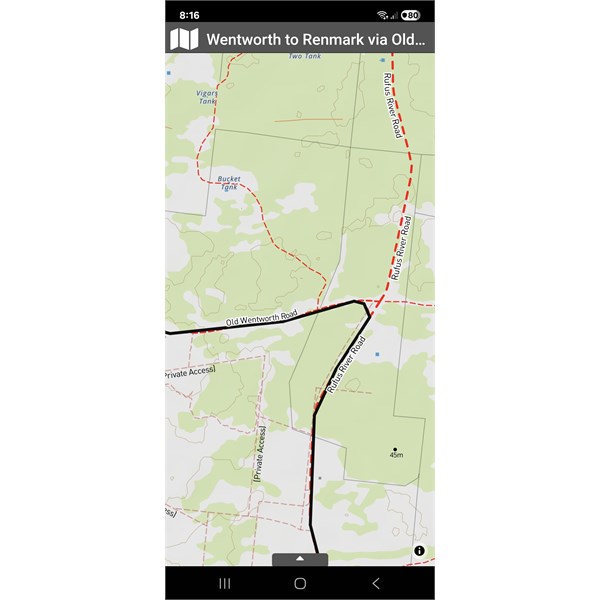
Rufus river rd
FollowupID:
929623
Follow Up By: Peter_n_Margaret - Saturday, Aug 02, 2025 at 09:27
Saturday, Aug 02, 2025 at 09:27

HEMA map, tracks from 2021 and 2023.
We have camped on Wompinni Station (now closed) several times, most recently in 2023.
It is the dead-end at the bottom left corner of the track on the river.
The most western of the two N-S tracks is the most interesting (all of the others are "roads"). There are some "keep out" signs which the Wompinni owners then told us were not legitimate and we should ignore. It passes through a forest reserve.
We also
camp in the Conservation
Park on the SA side (booking via SA NPs). There is border and trade history in there to explore.
Some areas in the
park have been subject to flooding in the past. Unless there was short term flooding, I can not imagine the main Rufus River road being closed to the east.
Cheers,
Peter
OKA196 motorhome
FollowupID:
929624
Follow Up By: Member - silkwood - Monday, Aug 04, 2025 at 18:48
Monday, Aug 04, 2025 at 18:48
If you end up around
Renmark and birdwatching appeals,
Gluepot Reserve is a short drive away, with lovely campgrounds and bird-hides.
Not a good spot if rain is on the cards, though. It's called
Gluepot for a reason.
Cheers,
Mark
FollowupID:
929644
Follow Up By: Peter_n_Margaret - Monday, Aug 04, 2025 at 19:06
Monday, Aug 04, 2025 at 19:06
We like
Gluepot too.
Be aware though that it is a dead-end, one way in and same way out, which is a pity.
Cheers,
Peter
OKA196 motorhome
FollowupID:
929645
Reply By: Member - Duncan2H - Saturday, Aug 02, 2025 at 09:26
Saturday, Aug 02, 2025 at 09:26
Travelling down through Murray Sunset and then carrying onto into
Big Desert NP and/or Ngarkat would be a nice way to drop a little further south..
You could head into
Big Desert from
Pinnaroo and spend a night at Blue Gums Campground (see your Place Entry, its lovely) before heading west into Ngarkat (or just continue on and do the "Border Track" down to Bordertown.. if you head into Ngarkat head over to the Baan
Hill Track or Jimmy's
Well Track and use one of those to drop further south with a view to getting down into the Coorong, so you can head into
Meningie and then pick up
the loop of land called
Narrung, ferry back to the "mainland", then the ferry across the Murray at
Wellington and then dropping down into
Victor Harbor through
Goolwa.
If you do
Narrung (pleasant drive, take the time to google David Unaipon beforehand and take a look at a $50 note before you go).
AnswerID:
648355
Reply By: Andrew M1 (NSW) - Saturday, Aug 02, 2025 at 09:42
Saturday, Aug 02, 2025 at 09:42
If you are going via
Renmark, then I would suggest you stay at
Plush's Bend Camping Area. We were there about 3 years ago, just prior to all the flooding. There are about 10
camping areas that are within metres of the river. You have to book/pay for the site, there is a large
sign as you enter giving details of how to book/pay for the site. We took a photo of the
sign then drove in and found a great spot, then booked and paid for it over the internet.
Directions, head out of
Renmark towards
Adelaide on the Sturt Hway, turn left down 23rd St (immediately after the distillery), after a 1km veer left onto Plush's Bend Rd, follow this (1.5km) to river. There are drive in areas along the river, look for
camping area number nailed to trees.
After pulling up it only took me 5 minutes to get 2 rods in the
water, then I started setting up the
camp site!!
AnswerID:
648357
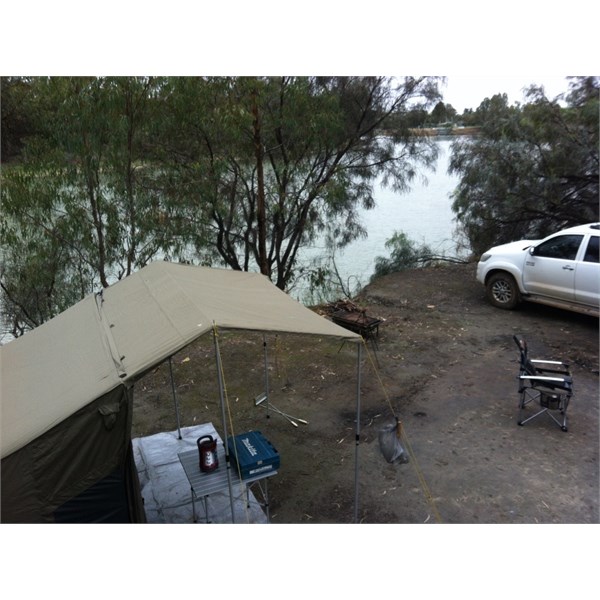
Reply By: Member - McLaren3030 - Sunday, Aug 03, 2025 at 08:35
Sunday, Aug 03, 2025 at 08:35
Hi Guys,
Back in 2015, at the start of a
Simpson Desert trip, we travelled from
Mildura to
Renmark on the Old Mail Road. This road follows the
Murray River on the Victorian side of the river. There are numerous tracks off this road leading to the river. This road is listed on both
Exploroz Traveller, and Hema. If the weather is wet, this road can be quite slippery.
First photo, I got “sucked” into a deep hole on the edge of the road after hitting a deep puddle, the road is actually at the right of the picture. Second photo is our first night
camp site down a track off the Old Mail Road. This
camp site is just down stream from
Lock 9, you can access this spot from the
Lock 9 access road.
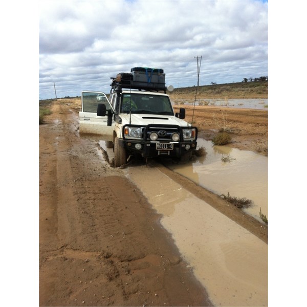
2015 Old Mail Road
2015 Old Mail Road
Macca.
AnswerID:
648362
Follow Up By: Member - nick boab - Sunday, Aug 03, 2025 at 09:31
Sunday, Aug 03, 2025 at 09:31
Macca , I watched this video while ago on old mail road . We use to
camp for many years at lock 7 at
Easter... one of my favourite spots great memories with friends and family.
Old mail rd sunset NP
FollowupID:
929628
Reply By: Garry L - Monday, Aug 04, 2025 at 19:38
Monday, Aug 04, 2025 at 19:38
Howdy
Duncan2H has a good suggestion - have done most of that.
Yellow Gums and Blue Gums are nice and very accessible without having to do the
Border Track, they're off the
Murrayville Nhill road.
Red Bluff at the bottom of the
Border Track isn't bad either but you are getting further south of
Victor Harbor.
The
Border Track is a days drive from
Murrayville to
Red Bluff with some nice sand hills and is currently damp due to rain so pretty easy going ( just got back yesterday from it )
You guys are also welcome to stay,
camp and use the facilities at my place if you like - I'm on a few acres 6k's south from
Murray Bridge.
Good luck and enjoy whatever option you choose
Cheers
Gazz
AnswerID:
648374
Follow Up By: ExplorOz - David & Michelle - Tuesday, Aug 05, 2025 at 19:16
Tuesday, Aug 05, 2025 at 19:16
Hi Gaz thats very kind of you thankyou! Would love to take up the offer but we’re on a timeline with a family visit being the reason we are going to VH. Next time for sure - would love to have more time to explore Swan Reach and
Big Bend area again.
FollowupID:
929648